


- 0:30 h
- 4.02 km
- 40 m
- 639 m
- 481 m
- 1,123 m
- 642 m
- Start: Schattdorf, Haldi cableway upper terminus
- Destination: Schattdorf, Haldi cableway lower terminus
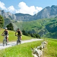
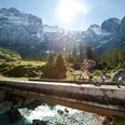
If you are looking for the ultimate kick and have a bike with long suspension travel and the appropriate equipment, then this is the downhill for you. The thrilling downhill experience through the steep Gosmer valley consists of a single trail featuring prepared corners, jumps and natural obstacles such as roots and rocks. The first part offers tight corners with challenging obstacles and passages with gradients of up to 30 percent. Next, on a short section of forest road, you branch off right into the Schattdorf protective forest and start the second part of the route – the newly developed free ride section. Its large, wide and steep abutments featuring fast corners provide optimum flow. The additional compressions and jumps provide the requisite kick, enough to quicken the pulse of any downhill devotee. The last part along the forest road then brings you back to your starting point, the lower terminus of the Haldi aerial cableway in Schattdorf.

Good to know
Pavements
Best to visit
Directions
Directions & Parking facilities
Author
Uri Tourismus AG
Organization
Bikegenoss Zentralschweiz
Nearby


