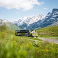
Four Lakes Trail


Fantastic mountain scenery around the mighty Titlis, unique flora, deep blue lakes and breathtaking views of the Central Swiss Alps – these are just some of the highlights of this hike.
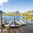
This itinerary of the Four Lakes Trail starts at the upper terminus of the Melchsee-Frutt aerial cableway. The path first leads to Lake Melch, the sparkling natural reservoir increasingly popular with anglers. At the water's edge is a pretty little chapel, in demand for weddings. The path leads directly via Müllerenhütte to Lake Tannen, a good place for a barbecue break as it benefits from sheltered seating. Tannalp is a little further, after which the path descends to enchanting Lake Engstlen, also a fishing destination.
The ascent to the Joch Pass begins at Lake Engstlen. The refuge up there offers refreshments, after which you descend to Lake Trüb on the other side of the mountain, where you can hire a rowing boat and admire the scenery from the water. The Untertrübsee restaurant on the path down to Engelberg is reputed to serve up the best meringues – worth a look in!
- 4:35 h
- 14.52 km
- 518 m
- 624 m
- 1,764 m
- 2,209 m
- 445 m
- Start: Talstation Stöckalp
- Destination: Bahnhof Engelberg
Waypoints

Good to know
Best to visit
Directions & Parking facilities
Additional information
Author
Obwalden Tourismus
Organization
Obwalden Tourismus
Nearby

