Marbachegg - Hürnli - Marbach


- 4:30 h
- 14.59 km
- 382 m
- 967 m
- 875 m
- 1,533 m
- 658 m
- Start: Talstation, Sportbahnen Marbachegg
- Destination: Talstation, Sportbahnen Marbachegg
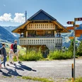
The hike starts from Marbachegg and leads past the reservoir in the direction of Oberlochsittli and Chadhus to the Imbrig Alp. The Jordi family manages the alp during the summer months and produces various alp cheeses such as Mutschli, raclette and goat cheese as well as alp butter in the alp dairy. In the Beizli there are warm as well as cold dishes for hungry and thirsty hikers. If you want to take a good piece of alpine cheese with you, you are in the right place.
The tour continues with a slight ascent over the Hürndliegg to the Hürnli. Also on this stretch you are constantly accompanied by the steep slopes of the Schrattenfluh. No wonder, numerous myths and legends are circulating around this mountain. At the Hürnli you can enjoy the unique view in peace and quiet. The Hürnli hut is located at 1497 m.a.s.l. in the Hilfern valley in the municipality of Marbach. It can be rented from the Marbach Ski Club from the beginning of June to mid-October. Around the hut there are several picnic areas and fireplaces.
After a rest, the route goes up and down in the direction of Schüberlsmoos and then runs downhill back to the starting point, the valley station of the Sportbahnen Marbachegg.
Good to know
Pavements
Best to visit
Directions
Tour information
Loop Road
Mountain Railway Tour
Stop at an Inn
Equipment
Gutes Schuhwerk, Regenjacke & genügend Trinkwasser für unterwegs gehören zu jeder Wanderung.
Weitere Tipps zum sicheren Wandern, Informationen zu Mutterkuhherden und Herdenschutzhunden und vieles mehr gibt es auf der Webseite der Schweizer Wanderwege.
Directions & Parking facilities
Plan your route with the help of the Google Route Planner.
Ein kostenloser Parkplatz steht bei der Talstation der Sportbahnen Marbachegg zur Verfügung.
Plan your trip with the BLS online timetable.
Additional information
Escholzmatt-Marbach Tourismus
Tourismusbüro Marbach
Dorfstrasse 61
CH-6196 Marbach
Telefon +41 (0)34 493 38 04
www.escholzmatt-marbach-tourismus.ch
Author
UNESCO Biosphäre Entlebuch
Organization
UNESCO Biosphäre Entlebuch
Author´s Tip / Recommendation of the author
Map
Die Sommer-Panoramakarte "Wandern" mit vielen interessanten Wandervorschläge rund um Marbach erhalten Sie unter: Escholzmatt-Marbach Tourismus
Nearby
