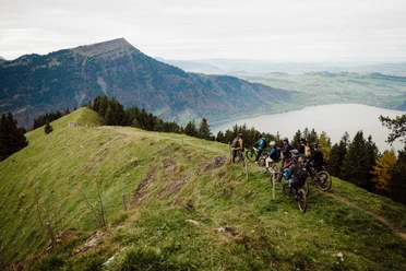
Around the Morgartenberg


Technically not too difficult mountain bike route around the Morgartenberg, past the Rothenthurm moor and through the Mostelberg holiday village. The route mainly runs on asphalt or gravel roads. On Mostelberg you can take the opportunity for a fun toboggan ride. This loop ends with a nice descent to Sattel.
- 2:45 h
- 22.87 km
- 702 m
- 701 m
- 749 m
- 1,250 m
- 501 m
- Start: Sattel
- Destination: Sattel
Good to know
Pavements
Best to visit
Directions
Tour information
Loop Road
Nature Highlight
Stop at an Inn
Directions & Parking facilities
From Bern towards Sattel:
Take the A1/E25/E27 motorway towards Zurich, Basel, Biel/Bienne and follow the signs towards Zurich. At the Wiggertal junction, keep right towards Gotthard, I, Lucerne, Reiden. At the Rotsee junction, keep right and follow the signs towards Schwyz. Leave the A4/E41 motorway at exit 39 towards Schwyz, Pfäffikon, Sattel and follow the signs towards Sattel, Einsiedeln.
From Ticino towards Sattel:
Take the A13/E43 motorway towards Lugano, Locarno and follow the signs towards San Gotthardo. Leave the A2/E35 motorway at exit 36 towards Schwyz, Altdorf Nord and then take the A4/E41 motorway. Leave the A4/E41 motorway at exit 39 towards Schwyz, Pfäffikon, Sattel and follow the signs towards Sattel, Einsiedeln.
Additional information
- If the Mülleren shooting range (Rothenthurm) is in use, the detour is always well signposted.
- The driving ban in the Mostelberg region does not apply to bikers, but only to motorized traffic.
Author
Erlebnisregion Mythen
Organization
Bikegenoss Zentralschweiz
Safety guidelines
Nearby


Download GPX file