Circular hike around the Göscheneralp reservoir


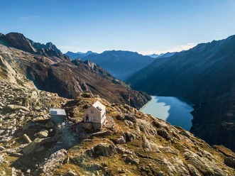
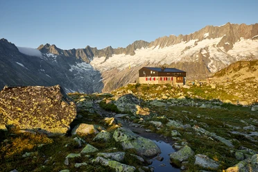
The Göscheneralp is the most romantically wild valley in the Alps. It is rich in water and also stones. The famous giant crystals from Planggenstock were found here. The circular hike is divided into three parts. In the first section, we hike through rocky alpine meadows; then it goes around the Egg on stone slabs, which can be dangerous when wet; and finally, we return through a charming moor landscape to the starting point. Those interested in the two themes water or climate can find materials at the Dammastock mountain restaurant, on the one hand on the Water Worlds Göscheneralp, and on the other hand an audio tour by myclimate about climate change and its effects on the Alpine world (climate audio trail).
Book your accommodation in the Andermatt Urserental holiday region here: booking.andermatt.ch!
Find experiences in the Andermatt Urserental holiday region here: andermatt.ch!
- 3:01 h
- 8.20 km
- 426 m
- 427 m
- 1,773 m
- 2,038 m
- 265 m
- Start: Dammagletscher restaurant at the dam of the reservoir
- Destination: Dammagletscher restaurant at the dam of the reservoir
Good to know
Pavements
- Trail (8%)Path (92%)
Best to visit
- suitableDepends on weather
Directions
The circular hike around the Göscheneralp reservoir begins at the post bus stop by the Dammagletscher Mountain Inn. For this mountain hike, first cross the dam wall. Then, a narrow path leads on the right side of the reservoir in a zigzag upwards to the first rock step and gently ascending to the junction Älpergen. Over the Planggen you reach a footbridge that crosses the Dammareuss. Then the path goes slightly downhill into the Chelenalp valley. Again you cross a footbridge. This leads over the Chelenreuss. In the second half of this magnificent circular hike, you follow a wide mountain path to a terrace with a wonderful view down the valley. In the Berg area, the path passes through a unique moor landscape with scattered mountain pines. Going downhill in the last section, you return near the dam to the starting point at the post bus stop. This circular hike is known for its scenic beauty, the glaciers, and the surrounding mountain ranges.
Tour information
Circular trail
Refreshment stop
Equipment
Good shoes, rain protection, and sun protection.
Recommended map material:
Directions & Parking facilities
- Getting thereBy car, we reach Göschenen on the A2. There, we leave the motorway, turn into the village, and reach the turnoff to the right towards Göscheneralp in the middle of the village. We follow the road to the Dammagletscher restaurant, where we find enough paid parking spaces.ParkingThere are enough paid parking spaces at the dam of the Göscheneralp reservoir. The circular hike around the Göscheneralp reservoir has been the most popular hike in the canton of Uri several times in recent years. A unique experience in the middle of the high alpine mountain world. If your fitness is sufficient, you can enhance the hike with a detour to the Damma hut, the Chelenalp hut, or the Bergsee hut.Public transportation
You can take the train to the Göschenen station and switch there to the post bus.
You can also order the Göscheneralp taxi from the Mattli-Wyrsch family from Göschenen (Tel. 041 885 10 86).
Additional information
Occasionally you can observe sheep, goats, and cattle grazing. Particularly interesting are the Boer goats, whose meat is marketed throughout Switzerland as Alpine kid goat. The Boer goats originally come from South Africa but fit very well into the romantically wild area.
Author
Markus Fehlmann
Organization
Verein Urner Wanderwege
Author´s Tip / Recommendation of the author
Keep an eye out for blueberries in summer. Maybe they are ripe. Then we recommend you enjoy this natural snack. In the fifties and sixties, the Göscheneralp was famous throughout Switzerland for its blueberries.
Safety guidelines
- Put on good footwear. In the middle section, the path goes over stone slabs that can be slippery.
Map
- Uri hiking map sheet "Gotthard", available from the Uri Hiking Trails Association (urnerwanderwege.ch)

Nearby


Download GPX file