Engelstock ROUND route


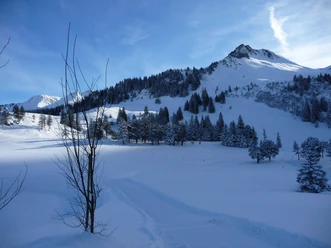
The ROUND route Engelstock is one of the most beautiful winter hiking trails in central Switzerland! A well-prepared, easily walkable winter hiking route around the Engelstock. The ROUND route Engelstock is accompanied by a stunning panorama of the all-around snow-covered Alps!
- 1:50 h
- 5.42 km
- 150 m
- 150 m
- 1,147 m
- 1,266 m
- 119 m
- Start: Mostelberg mountain station
- Destination: Mostelberg mountain station
Good to know
Pavements
Best to visit
Directions
Mostelberg mountain station 1174 m a.s.l. - Ängelstockweid 1149 m a.s.l. - Blüemlisberg 1164 m a.s.l. - Mostelegg 1265 m a.s.l. - Herrenboden 1178 m a.s.l. - Mostelberg mountain station 1174 m a.s.l.
Tour information
Familiy-Friendly
Loop Road
Mountain Railway Tour
Stop at an Inn
Equipment
Directions & Parking facilities
From Zurich via Zurich-Chur motorway, Schindellegi exit, direction Schwyz (approx. 40 min)
From Zug via Aegerital (approx. 20 min)
From Lucerne via Zug-Schwyz motorway, Schwyz exit, direction Pfäffikon-Sattel (approx. 40 min.)
There are parking spaces directly at the valley station of the revolving gondola Stuckli Rondo.
Southeastern Railway (SOB) from Rapperswil, Pfäffikon, Wädenswil, Einsiedeln, Lucerne, Arth-Goldau.
Train station "Sattel-Aegeri" (10 minute walk to the valley station of the gondola or the roller park). Voralpen-Express: Fast train connection Romanshorn-St.Gallen-Lucerne (stops in Biberbrugg and Arth-Goldau). Connecting buses from Biberbrugg (direction Rothenthurm-Sattel-Schwyz). Auto AG Schwyz (AAGS) from Schwyz (stop Sattel, gondola). Zugerland Transport Services (ZVB) from Zug
(bus line 1) to Oberägeri, change to bus line 9 to the final stop (stop Sattel, gondola)
Additional information
Author
Sattel-Hochstuckli AG / Schwyzer Wanderwege
Organization
Erlebnisregion Mythen

Nearby

Download GPX file