Hike from Holzwegen via Oberänzi to Romoos


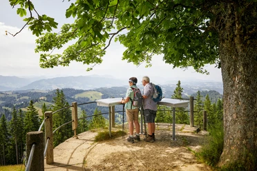
A fantastic view awaits you on this hiking tip. The first part is comfortably covered by PostBus from Romoos to Holzwegen. From here, the hike starts towards Oberänzi, where you can take a long break and enjoy a great view of the legendary Änziloch. It is not far to the famous Napf, where the Emmental, the Willisau region, and the UNESCO Entlebuch Biosphere meet. A detour of about 30 minutes (one way) will take you to the Napf. Back at Oberänzi, you then hike via Breitäbnet and Schwändi back to Romoos.
- 4:05 h
- 12.43 km
- 407 m
- 704 m
- 792 m
- 1,348 m
- 556 m
- Start: Holzwegen
- Destination: Romoos
Good to know
Pavements
Best to visit
Directions
Tour information
Loop Road
Nature Highlight
Equipment
Good footwear, rain jacket & enough drinking water for the journey are essential for every hike.
More tips on safe hiking, information about suckler cow herds and livestock guardian dogs, and much more are available on the website of the Swiss Hiking Paths
Directions & Parking facilities
The UNESCO Entlebuch Biosphere lies in the heart of Switzerland, centrally between Bern and Lucerne. You can reach Romoos via main road 10. From Entlebuch or Wolhusen, drive towards Doppleschwand and Romoos.
Plan your route using the Google route planner.
You can reach Romoos by public transport via Wolhusen (Bern-Lucerne railway line). From Wolhusen, take the PostBus to Romoos and further to Holzwegen.
Plan your trip with the SBB online timetable.
Additional information
Tourism Romoos
c/o municipal administration
Dorf 32
CH-6113 Romoos
Phone +41 41 480 13 73
[email protected]
Author
UNESCO Biosphäre Entlebuch
Organization
UNESCO Biosphäre Entlebuch
Author´s Tip / Recommendation of the author

Nearby


Download GPX file