


- 6:00 h
- 24.30 km
- 1,367 m
- 922 m
- 882 m
- 1,539 m
- 657 m
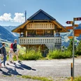
- Start: Flühli, Post Office
- Destination: Flühli, Postautohaltestelle Flühli, Post
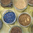
Even on the top of the Hilferenpass you can find moor land! The moor land Hilferen is a varied landscape between thin settled, wild "Flyschgebiet" and the annual inhabited moor landscape of the middle land: in the high location characterize alp meadows with dark spruce forests and flower-rich fen the picture. In the middle locations, moor meadows and spread meadows form a fascinating mosaic. Even in the low locations - on all-year admin-istered farms - you can still find big and coherent fen. The typical spread settlements are still received.
This part contains a day tour over the Hilferenpass with loads of woody hillside paths.
Specials in the moor of the Hilferenpass
O: Seven characteristic farms like you can just see them in the Entlebuch. Flat, stable, and barn floor are under the same roof. The hay stage overtowers the dwelling. The typical houses of Entlebuch belong to little real estates and were built between 1750 and 1850.
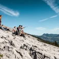
P: Here it shows a relief with the typical shape treasure of the alp: gorges and expanded slides on steep hillsides (Toregg, Steinwang).
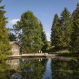
Q: At the foot of the Schrattenfluh you can see wonderful cirques with extensive fen (Aem-mental, Tor, Hefti, Baettenalp).
R: Bog Taellenmoos: The name comes from Daehle=Mount pine.
V. The Schrattenfluh attracts attention with typical forms of karst like sinkholes and branched cave systems. In the opposite of the wet moor land, on the bare karst does not exist ground level water because it seeps away belowground through clefts and gaps.
Note(s)
You can reach the starting point Fluehli with the bus from the railway station Schuepfheim.
The route is marked with the pointer «Moorlandschaftspfad» and can also be made in the opposite direction.
Information about the timetable you can find on www.postauto.ch
On the Kemmeriboden you can choose between two possibilities: You can take the bus to Wiggen and then further with the train. Or you can take the other part «Hab-kern/Soerenberg» of the Moorlandschaftspfad.
See also
Further informations (Brochure «Moorlandschaftspfad» and «Marbach/egg»):
UNESCO Biosphäre Entlebuch
Biosphärenmanagement
Chlosterbüel 28
CH-6170 Schüpfheim
Telefon: 0041 (0)41 485 88 50
Mail: [email protected]
page: www.biosphaere.ch
Good to know
Pavements
Best to visit
Directions
- Kemmeribodenbad - Schibehüttli - Imbrig - Tan - Hind. Bättenalp - Toregg - Hilferepass - Schwändi - Torbach - Flühli Post
- Die Route ist mit dem Signet «Moorlandschaftspfad» markiert und kann auch in umgekehrter Richtung begangen werden.
- An diese Strecke können die Etappen «Habkern/Sörenberg» oder «Kleine Entle» angeknüpft werden.
Variante
Gondelbahn Marbach-Marbachegg (1483M); Einstieg in den Moorlandschaftspfad über Wittefäre-Chadhus-Imbrig; Zeitersparnis 30 Minuten
Informationen zur Gondelbahn finden Sie unter: Sportbahnen Marbachegg
Tour information
Nature Highlight
Stop at an Inn
Equipment
Gutes Schuhwerk und eine allwettertaugliche Ausrüstung sind unerlässlich. Empfehlenswert sind Fernglas, Pflanzen- und Tierbestimmungsbücher, evtl. auch ein Frottetuch, mit dem nach dem Barfusswandern die Füsse getrocknet werden können.
Directions & Parking facilities
Die UNESCO Biosphäre Entlebuch liegt im Herzen der Schweiz, zentral zwischen Bern und Luzern. Mit dem Auto erreichen Sie verschiedenen Etappen über die Hauptstrasse 10.
Planen Sie Ihre Route mit Hilfe des Google Routenplaners.
An den Ausgangsorten hat es diverse kostenlose sowie kostenpflichtige Parkplätze.
Mit dem öffentlichen Verkehr erreichen Sie die verschiedenen Etappen via Bahnlinie Bern-Luzern.
Planen Sie Ihre Reise mit dem SBB Online Fahrplan.
Additional information
UNESCO Biosphäre Entlebuch
Chlosterbüel 28
CH-6170 Schüpfheim
Telefon +41 (0)41 485 42 50
www.biosphaere.ch
Möchten Sie das Moor mit einem Experten erkunden? Gerne organsiert die UNESCO Biosphäre Entlebuch geführte Wanderungen bzw. Exkursionen. Informieren Sie sich beim Biosphärenzentrum: [email protected] oder Tel. +41 (0)41 485 42 50.
Author
UNESCO Biosphäre Entlebuch
Organization
UNESCO Biosphäre Entlebuch
Author´s Tip / Recommendation of the author
Ein Erfrischung in der Kneippanalge Schwandalpweiher in Flühli ist purer Balsam für die müden Füsse.
Safety guidelines
Handy-Empfang ist teilweise schwierig bis unmöglich.
Map
Die Broschüre «Moorlandschaftspfad» mit vielen interessanten Informationen zu den einzelnen Etappen erhalten Sie im Biosphärenzentrum oder können Sie direkt hier bestellen.
Nearby

