- 2:27 h
- 7.34 km
- 34 m
- 1,039 m
- 1,001 m
- 2,040 m
- 1,039 m
- Start: Berghaus Schönbüel
- Destination: Brünig Pass
This route leads in five daily stages from Pilatus over the geographical center of Switzerland to the Stanserhorn, always at a lofty height and with fantastic views of countless Alpine peaks and a dozen Alpine edge lakes.
With the steepest cogwheel railway in the world from Alpnachstad or by cable car from Kriens, you reach the Pilatus summit, a 2132 meter high viewpoint and spectacular starting point of the Obwalden Höhenweg. The view reaches far down to Lake Lucerne and over countless Alpine peaks. Alternating between fir forests and alpine meadows, you hike on cosy paths right into the moorland Glaubenberg in the area of the Entlebuch Biosphere Reserve.
Cheese and sausage directly from the alp are a delight and provide energy for the scenic hike over the Glaubenbielen Pass to the panoramic world of Lungern-Schönbüel. Höchgumme and Wilerhorn, two rewarding summit goals on the way to the Brünig Pass, promise breathtaking views down to the turquoise Brienz Lake.
Past picturesque alpine chapels, the path rises to the geographical center of Switzerland at Älggialp. With the glaciated Titlis in view, you reach the Melchsee-Frutt lake plateau at a lofty height. The route finally explores the east flank of the original Melch valley and offers beautiful views of the wild landscape. With some luck, you may spot chamois or even an eagle on the way to the Stanserhorn.
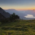
Stage 3: The popular hike Schönbüel-Brünig Pass stimulates all the senses and does not shy away from beautiful views. A spectacular vantage point is the Gibel, with views down to Lake Brienz and Lake Thun. Ridge hiking to Wilerhorn, summit ascent worth doing.
Good to know
Best to visit
Author
Obwalden Tourismus
Organization
Obwalden Tourismus
Author´s Tip / Recommendation of the author
Nearby