


- 10:30 h
- 34.90 km
- 1,400 m
- 1,400 m
- 434 m
- 873 m
- 439 m
- Start: Seelisberg, Rütli
- Destination: Brunnen
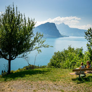
The Swiss Path winds around the deep Lake of Uri, sometimes high up, then again directly on the shore. Sometimes it leads you over steps carved into the rock, then it runs along wide, comfortable paths, past many resting and bathing places. Again and again you can enjoy a magnificent view of the lake and the surrounding mountains. Thanks to the boat service, you have a choice of many possible starting points and destinations.
The initiators succeeded in linking a maximum sense of home with the trail. At the centre is the Rütli, an unspectacular meadow that is emotionally charged by historical symbolism like no other place in Switzerland. Tell's Plateau with the Tell's Chapel is also part of the obligatory visit programme.
The attachment of the Swiss to this path is further strengthened by the idea that the Swiss Path is divided into 26 cantonal sections. Their order results from the cantons' entry into the Confederation. The length of the cantonal sections, in turn, is based on the cantonal population in 1991, when each person was symbolically given 5 millimetres.

Good to know
Pavements
Best to visit
Directions
Tour information
Cultural Interesting
Familiy-Friendly
Mountain Railway Tour
Stop at an Inn
Tour with Dog
Equipment
Directions & Parking facilities
P+Rail Brunnen – Bahnhofstrasse 46 – 6440 Brunnen
Train and bus. From Zurich and Lucerne, you can get to Brunnen every hour and half hour. The same applies from Ticino. There is a bus from Brunnen railway station to the landing stage. But you can reach the shores of Lake Lucerne comfortably on foot in just 7 minutes. www.sbb.ch
Lake taxi. If you want to travel to the Rütli or leave the Rütli at a specific time, there is also a lake taxi in Brunnen. The boat can take 7 people. The 10-minute journey to the Rütli costs around CHF 100. More information at: Speedy taxi boat. From the Rütli boat station you can reach the Schwurplatz and the Rütli meadow either on the gravel path or on foot via the steps in 7-10 minutes.
Additional information
The Swiss Path leads you through the homeland of William Tell. En route, you will spot traces of the past and encounter mythical heroes. You can engage with different images of Switzerland and rediscover the country for yourself. www.wiegederschweiz.ch
Literature
ISBN 978-3-03818-334-1
Author
Jonas Ulrich
Organization
Schwyzer Wanderwege
Author´s Tip / Recommendation of the author
Map
ISBN 978-3-302-32599-6
Nearby


