Wichelsee round

- 1:30 h
- 10.48 km
- 5 m
- 41 m
- 432 m
- 473 m
- 41 m
- Start: Sarnen station
- Destination: Alpnachstad station
Good to know
Best to visit
Directions
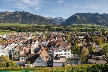
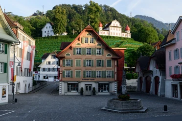
A few steps from Sarnen station lead to the village square with the town hall, a witness to the centuries-old confederate independence of the canton of Obwalden. After crossing the town hall bridge, the hiking trail heads north, sometimes on the left, sometimes on the right along the Sarneraa river to the Aa bridge at the former Kägiswil railway station, over which the Kernserstrasse runs. Crossing this and the railway tracks, you turn northeast and, after passing under the motorway, reach the Wichelsee nature reserve.
The area, developed around the lake dammed in 1957, was designated in 2005 as a protected habitat for rare animal and plant species as well as a valuable landscape and recreational area. Here, a variety of different bird species gather and breed, enriched by rare migratory birds and winter guests. Artificially created ponds are home to numerous amphibian species.
In 2007, a fish ladder was built at the dam of the Sarneraa power plant, where fish can now ascend back to the lake and the upper Sarneraa along their natural migration route in the residual water. Various benches and fire pits invite you to linger and observe nature.
For the return trip from Alpnachstad, you can conveniently take the Zentralbahn to Sarnen, which runs every half hour.
Tour information
Nature Highlight
Directions & Parking facilities
On the A2 from Lucerne through the tunnel switch to the A8 towards Interlaken, then switch to Sarnen and take the Sarnen Nord exit.
From Interlaken via Brünig on the A8 to the Sarnen Nord exit.
From Lucerne or Interlaken with the Lucerne-Interlaken Express to Sarnen.
From Alpnachstad, travel comfortably back to Sarnen with the Zentralbahn S5.
Author
Obwalden Tourismus
Organization
Obwalden Tourismus
Nearby