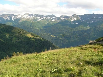
Bedretto


The route starts at the Gotthard Pass, where bikers either pedal about 1.5 hours or conveniently reach by post bus. From the hospice, follow the cantonal road; before the tunnel, turn left onto the hiking trail. Shortly afterwards, you reach the alp road. Above the village of Villa, there is a huge protective wall; here, continue right on the alp road. Shortly after crossing the Ri di Bedretto stream, the hiking trail turns left towards Bedretto. This section, especially the first 100 meters of elevation, represents the biggest technical challenge for riding. After the small village Ronco, the climb towards Alpe Cristallina begins. Then the biggest part of the ascent is done – continue to Alpe Piano di Pescia. On a beautiful trail, the ride continues to Cascina Nuova. The forest road leads to Culiscio, and on the street it goes over Nante to Airolo train station.
- 4:30 h
- 35.20 km
- 913 m
- 1,863 m
- 1,142 m
- 2,115 m
- 973 m
- Start: Gotthard Pass
- Destination: Airolo Train Station
Good to know
Pavements
Best to visit
Directions
Tour information
Nature Highlight
Stop at an Inn
Equipment
- Clothing appropriate for the weather
Directions & Parking facilities
The Gotthard Pass is very well accessible via the pass road from Airolo and Hospental.
There are several parking options directly at the Gotthard Pass.
The Gotthard Pass is accessible by post bus from Airolo or Andermatt. The timetable is as follows: SBB/Postbus Timetable
Additional information
For further questions, please contact: Andermatt holiday region, +41 41 888 71 00, [email protected]
Author
Andermatt-Urserntal Tourismus GmbH
Organization
Région de vacances Andermatt
Author´s Tip / Recommendation of the author
- In Airolo, load the bike onto the train and have it transported to Göschenen and Andermatt.
Safety guidelines
Pay attention to the weather forecasts and path and road closures.

Nearby