Bike route Furka Höhenweg (Urschner Höhenweg)


- 5:00 h
- 34.28 km
- 1,097 m
- 1,097 m
- 1,430 m
- 2,309 m
- 879 m
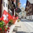
- Start: Andermatt train station
- Destination: Andermatt train station
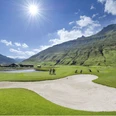
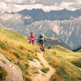
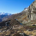
The route leads from Andermatt train station through the valley floor towards Realp, where the path rises up to Tiefenbach. Now single trails are on the agenda. The developed trail continues from Tätsch into the valley basin of the Lochberg and then ups and downs towards Lutersee. As a reward, a breathtaking panoramic view awaits there. Afterwards, the route leads downhill along the Golfrundweg onto the Reuss dam towards Giessen and back to Andermatt train station.
Good to know
Pavements
Street
Asphalt
Gravel
Trail
Path
Best to visit
suitable
Depends on weather
Directions
Andermatt – Giessen – Golfrundweg – Rossmettlen – Blauseeli – Lochberg – Realp – Hospental – Andermatt
Tour information
Loop Road
Stop at an Inn
Author
Andermatt-Urserntal Tourismus GmbH
Organization
Région de vacances Andermatt
Author´s Tip / Recommendation of the author
- Complete the route with an e-mountain bike
- Route in reverse direction: Furkapassstrasse to Tiefenbach-Lochberg-Rossmettlen-Golfrundweg-Andermatt
Nearby

