Buochs-Stansstad

Travel along the harbor pier (beware of entering and exiting boats). Next follows a swimming zone (no boating zone). Therefore, paddle outside the yellow buoys.
1.0 km:
Continue paddling along the shore. Beware of scheduled ships at Ennetbürgen ship station.
from 3.0 km:
There are various rest areas (gravel beaches) in the forest, some with fire pits but without toilet facilities.
4.5 km:
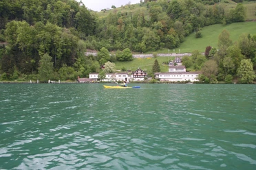
At the end of the Bürgenstock is a gravel beach with a ship docking place, grilling facilities, and a small shelter with table and bench. Paddle on for the continuation around the Bürgenstock.
6.5 km:
Rock face at Obermatt (former quarry). Rockfalls have occurred here, so keep a distance from the rock face and paddle quickly past.
7.0 km:
The Obermatt restaurant is an ideal rest spot. The exit is located at the end of the facility, to the right of the small harbor building.
from 8.0 km:
After Untermatt follows a section with rockfall danger. The zone is marked with signs, a minimum distance of 100 meters is prescribed, and swift paddling past is recommended.
11.0 km:
Beware of scheduled ships at Kehrsiten Bürgenstock ship station.
12.5 km:
Beware of scheduled ships at Kehrsiten Dorf ship station.
13.0 km:
Between the two ship stations is a private campsite that must not be entered without permission. Shortly after the Kehrsiten Dorf ship station, you can stop at Seehotel Baumgarten.
15.5 km:
The exit in Stansstad is at General-Guisan-Quai.
- 5:30 h
- 15.52 km
- 434 m
- 434 m
- 0 m
- Start: Water Sports Center Nidwalden (south side of the boat harbor)
- Destination: General-Guisan-Quai Stansstad
Good to know
Best to visit
Directions
Tour information
Stop at an Inn
Equipment
Directions & Parking facilities
Additional information
Canoe Rental
Author
Reto Wyss (Kanuwelt Buochs)
Organization
Luzern Tourismus
Safety guidelines
Weather
The weather development should be monitored throughout the entire route. The rain radar from MeteoSwiss is particularly helpful. In case of uncertain weather conditions, it is better to paddle shorter distances with various exit points. Adjust clothing for the weather (sun, rain, and cold protection).
Water, Wind and Waves
Lake Lucerne, like any other lake, is constantly exposed to changing conditions. For canoe tours, water temperature, wind, and waves are decisive. Tours should only be undertaken by experienced paddlers in cold water (below 15° Celsius). Stay near the shore or exit if there is strong wind and/or waves and wait for the wind and waves to subside at the shore. Storm warning: There are two levels. The strong wind warning (40 blinks per minute) indicates the danger of gusts up to 60 km/h, and the storm warning (90 blinks per minute) indicates gusts over 60 km/h.
Safety
Besides natural dangers such as wind and waves, other traffic participants on the lake must be especially observed. Scheduled ships and professional fishermen, as well as sailboats and swimmers, always have the right of way over canoeists. Keep distance from all other (motor) boats and make eye contact when crossing.
Nearby