Circular hike Luthern Bad - Napf


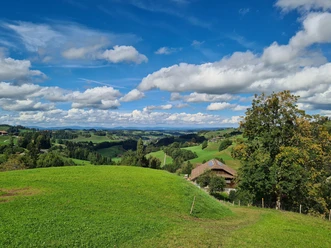
Start in Luthern Bad and follow the hiking trail on the left bank of the Luther to the Mittler-Ey farm. The path then steeply continues through a short forest section up the ridge of the hill to Alp Trachselegg. The first beautiful view opens up before you. Afterwards, it continues over the meadow uphill towards the mountain forest in the direction of Napf. The last part leads through the forest where you finally reach the summit with the mountain hotel and the wonderful panoramic view. For the return path from Napf to Luthern Bad, follow the route towards Niederänzi. First down the meadow, then through the mountain forest. At the first large clearing, you must turn right at the Bernese hiking trail sign. After a longer forest section, you reach Alp Niederänzi. Here, just before the farm, the path descends to the right along the meadow at the forest edge. Later, the path alternates between forest and meadows with views into the valley. After a short, steep descent, you reach Luthern Bad.
- 3:15 h
- 8.59 km
- 572 m
- 572 m
- 873 m
- 1,405 m
- 532 m
- Start: Luthern Bad
- Destination: Luthern Bad
Good to know
Pavements
Best to visit
Directions
Luthern Bad - Hinder Ey - Trachselegg - Napf - Alp Niederänzi - Badegg - Luthern Bad
Tour information
Loop Road
Stop at an Inn
Summit
Equipment
- Clothing suitable for the weather
- Good footwear
- Hiking poles are recommended
- Camera
- Day backpack
Directions & Parking facilities
Parking spaces are available
By train to Zell, from there post bus to Luthern Bad.
Additional information
Author
Willisau Tourismus
Organization
Willisau Tourismus
Author´s Tip / Recommendation of the author
In Luthern Bad you will find several sacred buildings:
- Source of power Badbrünneli with the healing water
- Pilgrimage church
- Arm and foot bath
How is the weather? Here you can access the webcams.
Nearby

Download GPX file