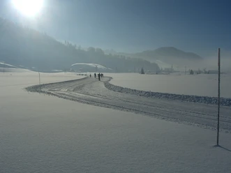
Finnenloipe Rothenthurm 3 km


Our unique moorland in winter is crossed by a beautifully designed cross-country ski trail. The 3 km loop has no elevation changes and is very suitable for beginners. The route is illuminated for evening training. The trail is prepared for both classic and skating techniques.
- 0:20 h
- 3.12 km
- 14 m
- 13 m
- 908 m
- 921 m
- 13 m
- Start: Rothenthurm (100 m from the station)
- Destination: Rothenthurm (100 m from the station)
Good to know
Best to visit
Tour information
Loop Road
Stop at an Inn
Equipment
Directions & Parking facilities
From motorway A4, exit Schwyz via Schwyz/Sattel or from motorway A3, exit Samstagern via Biberbrugg to Rothenthurm
- Pay parking spaces on Müllernstrasse
- Market hall parking lot
Direct connections exist with the Voralpen-Express from the direction of St. Gallen/Rapperswil and Lucerne/Küssnacht. From Lucerne, Rothenthurm is reachable by Voralpen-Express in about 50 minutes. Access from the station and bus stop is via the station underpass!
Alternatively, a direct bus runs from Schwyz to Rothenthurm station bus stop.
Note: This trail falls within the validity of the Loipen-Hit Schwyz, which includes convenient public transport round trip as well as the day ticket for the trail. More information at https://unterwegs.sob.ch/de/stories/loipen-hit
Additional information
Changing rooms
At Rothenthurm station, changing facilities are available:
- Changing possibility
- Lockable lockers
- Restrooms
Trail condition and webcam at www.finnenloipe.ch
Author
Finnenloipe / Schwyzer Wanderwege
Organization
Erlebnisregion Mythen
Author´s Tip / Recommendation of the author
Loipen-Hit Schwyz
Access the trail with a cross-country skiing day ticket including convenient round-trip travel: https://unterwegs.sob.ch/de/stories/loipen-hit
Cross-country Skiing Lessons
www.nordic-sportshop-rothenthurm.ch
Daily trail report at www.finnenloipe.ch
Nearby


Download GPX file