Flühli - Hilfern Pass - Toregg - Hengst


The route starts in the village of Flühli in Entlebuch and initially leads over alpine paths and meadow trails through typical pre-Alpine landscape. The steady ascent through light forest and open meadows leads to the Hilferen Pass, a traditional crossing between Escholzmatt and Flühli.
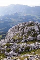
Behind the pass, the path crosses beneath the Strick, on sometimes narrow but clearly visible trail. The landscape is characterized by Schrattenkalk, rugged rock formations and alpine flora. Surefootedness is required on this section.
The final ascent runs over the open southeast flank of the Hengst and offers an increasingly wide view. The summit rewards with an impressive panoramic view over Entlebuch, the Central Swiss Alps as well as the Swiss Plateau.
- 5:10 h
- 9.71 km
- 1,360 m
- 172 m
- 897 m
- 2,085 m
- 1,188 m
- Start: Flühli village
- Destination: Hengst
Good to know
Pavements
Best to visit
Tour information
Summit
Equipment
Good footwear, a rain jacket & enough drinking water for the way belong to every hike.
More tips for safe hiking, information about suckler cow herds and guardian dogs and much more can be found on the website of the Swiss Hiking Routes.
Directions & Parking facilities
You reach Sörenberg via main road 10 towards Schüpfheim and from there to Flühli Sörenberg to the village centre of Sörenberg.
In summer, you can reach Sörenberg via Sarnen - Giswil over the Glaubenbielen Pass.
You can park your car free of charge at the Flühli village car park
You can reach Sörenberg by public transport via Schüpfheim (Bern-Lucerne railway line). From Schüpfheim, take the post bus to Sörenberg, post office. Plan your journey with the SBB online timetable.
Author
Sörenberg Flühli Tourismus
Organization
UNESCO Biosphäre Entlebuch
Nearby


