Göscheneralp-Göschenen


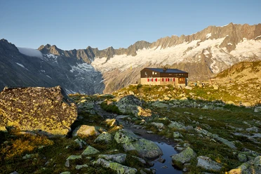
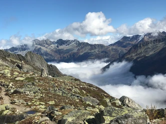
The beauty and diversity in this mountain valley are captivating. Hikers are accompanied by the view of mighty glaciers, gigantic rock walls, beautiful mountain ranges, blooming alpine meadows, and crystal-clear small lakes. From the natural dam in Göscheneralp, the leisurely hike starts by going down the dam into the valley. From the dam, there is a magnificent view of the surrounding mountains with glaciers and rock walls. After the first descent, the route passes small mountain lakes and the campsite. The lakes invite for a short break and cooling off. Along the young Göschenerreuss river towards Göschenen, you walk past lush green meadows and through small forests into the small village of Göschenen. There are various rest spots on the way to enjoy and admire nature even more.
- 2:35 h
- 9.17 km
- 679 m
- 1,106 m
- 1,786 m
- 680 m
- Start: Göscheneralp
- Destination: Göschenen Railway Station
Good to know
Pavements
Best to visit
Directions
Tour information
Nature Highlight
Stop at an Inn
Tour with Dog
Equipment
- Weather-appropriate clothing
- Good footwear
- Hiking poles are recommended
- Binoculars
Directions & Parking facilities
You reach the Göscheneralp valley via Göschenen. Göschenen is located directly at the A2 motorway exit.
There are parking spaces directly at the Göscheneralp reservoir.
You can reach the Göscheneralp valley by bus, where the two huts are located. The timetable is as follows: PostBus timetable
Additional information
For further questions, please contact: Andermatt holiday region, +41 41 888 71 00, [email protected]
Author
Andermatt-Urserntal Tourismus GmbH
Organization
Région de vacances Andermatt
Author´s Tip / Recommendation of the author
- Mountain guesthouses Dammagletscher and Göscheneralp
- Geissenparadies Göscheneralp
- Water trail
Safety guidelines
Pay attention to the weather forecasts. In the Alps, the weather can change quickly.
Nearby

