Jochpass - Graustock Hike


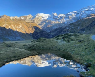
The hike to Graustock offers us a mountain trail. We can expect breathtaking views deep into the 700 m high north face of the Graustock and into the Engelberg valley. From the destination, we enjoy a magnificent panorama over the peaks Titlis, Spannort, Rigi, Mittelland, and Pilatus, as well as the Bernese peaks Wetterhörner, Schreckhorn, and Finsteraarhorn.
In early summer, large snow cornices can still protrude over the ridge, and snow bridges over karst areas can collapse when stepped on. Caution is therefore advised in these areas! Orientation is easy in good visibility; in poor visibility, especially the descent can be a challenge. The ridge is exposed to the southeast. Special attention must be paid to the weather report, as the entire route is very exposed.
- 2:20 h
- 5.06 km
- 416 m
- 416 m
- 2,203 m
- 2,608 m
- 405 m
- Start: Mountain station Jochpass (2,213 m)
- Destination: Graustock (2,608 m)
Good to know
Pavements
Best to visit
Directions
Ascent:
We take the Engelberg-Trübsee gondola first to the Trübsee station, then continue by chairlift up to Jochpass (2207 m).
Route description:
From Jochpass there is a hiking trail, marked white-red-white, leading up to the point 2324 m (Swisstopo).
Descent:
The descent follows the same path as the ascent
Tour information
Mountain Railway Tour
Equipment
Sturdy shoes, sun protection, and hiking poles are advantageous.
Directions & Parking facilities
On the A2 motorway to the Stans Süd exit, then continue on the cantonal road to Engelberg
Parking lot of the Engelberg-Trübsee gondola in Engelberg
By train to Engelberg station, then by gondola and chairlift to Jochpass
Additional information
Author
Engelberg - Titlis Tourismus
Organization
Engelberg-Titlis Tourismus
Safety guidelines
In early summer, large snow cornices can still protrude over the ridge, and snow bridges over karst areas can collapse when stepped on. Caution is therefore advised in these areas! Orientation is easy in good visibility; in poor visibility, especially the descent can be a challenge. The ridge is exposed to the southeast. Special attention must be paid to the weather report, as the entire route is very exposed.

Nearby