Moorland Trail Stage 4: Moorland Glaubenberg


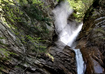
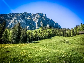
The largest moorland in Switzerland extends partially into the adjacent Obwalden area. It covers 130 km2 and also includes the second largest total area of raised and lowland moors. Outstanding is the importance of the raised bogs, which are the best developed in the whole of Switzerland. Water biotopes such as ponds, small lakes, tussock grass, springs, streams and waterfalls are preserved in great variety along this stage.
In the moorland especially notable is the extensive lowland moor Gürmschmoos with the large building for storing litter. The legendary Wasserfallenegg with the Drack. The Dragon is buried in the pine forest north of the signpost (P.1729) within the stone wall. The Änggelauenenseeli – the only natural lake in Entlebuch – lies in the landslide area at the foot of the Fürstein.
In the Glaubenberg/Wasserfallen area there are several Swiss Army shooting ranges. Detailed information and shooting dates can be found under "Safety instructions."
Moorland Trail UNESCO Entlebuch Biosphere
Discover here all stages of the five-day adventure through the Entlebuch moorlands.
Package offer
While you hike on the signposted Moorland Trail, enjoy the fascinating natural landscapes and savor the packed lunch at the nicest little spots, your luggage travels to the next overnight location. Here too, you enjoy a great variety – from overnight stays in a tipi on the alp to a 3*-hotel with a regional 4-course menu – and fall into a deep, restful sleep. Here is the package offer
- 4:50 h
- 13.93 km
- 854 m
- 503 m
- 1,022 m
- 1,796 m
- 774 m
- Start: Finsterwald (Entlebuch), Finsterwald post bus stop, Gfellen
- Destination: Flühli, alpine restaurant Stäldeli
Good to know
Best to visit
Directions
- Gfelle - Brüedere - Unter Gründli - Chlusmättli - Wasserfallenegg - Schönebüel - Stäldili
- The route is marked with the signet «Moorland Trail» and can also be walked in the opposite direction.
- The stages «Glaubenberg Stage 2» or «Small Entle» can be linked to this route.
Variants
Descent to Flühli: 1h30, 490 m ascent
Ascent from Flühli: 2h05, 490 m ascent
Tour information
Nature Highlight
Stop at an Inn
Equipment
Good footwear and all-weather equipment are indispensable. Recommended are binoculars, plant and animal identification books, and possibly a terry cloth towel to dry your feet after barefoot walking.
Directions & Parking facilities
The UNESCO Entlebuch Biosphere is located in the heart of Switzerland, centrally between Bern and Lucerne.
Plan your route with the help of the Google route planner.
Arrival: You can reach Finsterwald by public transport via Entlebuch (Bern-Lucerne rail line). From Entlebuch you take the post bus to Finsterwald.
Departure: From Sörenberg the post bus goes in the direction of Schüpfheim, where you have connections to Bern and Lucerne by train.
Plan your trip with the SBB online timetable.
Additional information
Chlosterbüel 28
CH-6170 Schüpfheim
Tel. +41 (0)41 485 42 50
[email protected]
www.biosphaere.ch
Author
UNESCO Biosphäre Entlebuch
Organization
UNESCO Biosphäre Entlebuch
Author´s Tip / Recommendation of the author
Bring a plant book to look up the diverse flora.
Safety guidelines
Mobile phone reception is partially difficult to impossible.
Important info
In the Glaubenberg/Wasserfallen area there are several Swiss Army shooting ranges. Detailed information and shooting dates can be found here. Entering the danger zone is life-threatening and therefore forbidden. Instructions from the cordon posts must be followed.
Map
The brochure «Moorland Trail» with many interesting information about the individual stages is available at the Biosphere Centre or can be ordered directly here.
Nearby