Sahli - Glattalp


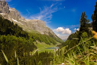
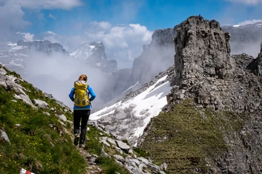
The hike starts at Saliboden just behind the Saliseeli. Here are the first power plant buildings of the electricity company of the district of Schwyz. In the Tröli go over the bridge of the Ruosalperbach. Then follow the alp road. Follow the bends of the natural road to point 1280. Then turn left. Now the mountain path winds in a few more bends to a first high plateau. The view opens up to Alp Milchbühlen and ahead to the mighty rock wall to Glattalp. To the right tower the Mären, to the left the Hängst. At Mütschen it then goes through typical karst area before reaching the plateau of Glattalp.
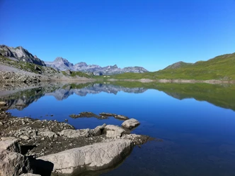
The panorama offered at Glattalp is unique. In winter this is the coldest place in Switzerland. In summer a large alp framed by numerous distinctive mountain peaks. The most striking are the Höch Turm and right next to it the Ortstock. Even if the eye is deceived, the Ortstock is about 51 meters higher. Left of the Höch Turm sits the Gross Chilchberg and right in the valley front is the Pfaff, an easily accessible hiking mountain. On the right mountain chain are the Mären, the Signalstock and the Jegerstöck.
- 2:04 h
- 4.32 km
- 749 m
- 29 m
- 1,146 m
- 1,869 m
- 723 m
- Start: Sahli
- Destination: Glattalp
Good to know
Best to visit
Directions
The starting point is Sahliboden, to the left over the bridge of the Ruosalperbach. Follow the natural road to point 1280. Turn left and follow the marked path over Läcki to Chneu. Then through the wild Chrümpfen up to Mütschen and the destination Glattalp.
Tour information
Mountain Railway Tour
Nature Highlight
Stop at an Inn
Equipment
Directions & Parking facilities
Additional information
Descent from Glattalp by aerial cableway, attention to timetable. Aerial Cableway Sali-Glattalp
Detour to the SAC hut Glattalp SAC Hut Glattalp
Author
Stoos-Muotatal Tourismus / Schwyzer Wanderwege
Organization
Schwyzer Wanderwege
Author´s Tip / Recommendation of the author
Safety guidelines
Nearby