Around Sahli


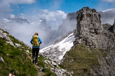
The starting point is the bus stop "Schlänggen" at the front of Sahli. Here the path climbs steeply south over the Rinderplangg. The soon flowing drops of sweat are rewarded by the quickly gained altitude. From the Vordersten huts, the path leads eastwards without significant ascent to the Waldisee, which fits perfectly into the landscape of the back Bisistal.
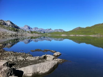
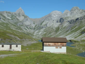
The reservoir built in 1960 is not suitable for swimming, but benches on the lakeshore invite you to linger and enjoy the magnificent view. After a well-deserved rest, the path takes you over the Muota to Gross Gade. After a short stretch on the natural road towards Gwalpeten, the path branches left to Spitzbächab (P 1384 m). Here the view towards the valley exit with the blue-glowing Sahlisee surprises you. You follow the widely visible path through the Plangg towards Milchbüelen. At the meeting with the Glattalp path, you descend a few meters to the road and follow it to Milchbüelen. Here the view opens to the impressive waterfall, which plunges over several stages down the opposite slope. After the idyllically situated Alp Milchbüelen, it goes quickly forward. Along the way, you will see the Eigelihütte on the left below, where the folk musician Rees Gwerder was also shaped in his youth by the landscape and its character. At Feldmoos, you will have to walk a few meters on the asphalt road before the path leads left down through the Plangg to the Schmallauistrasse. On this road, you hike to Salihöchi and then turn towards the valley exit back to the starting point.
- 3:30 h
- 10.55 km
- 605 m
- 605 m
- 1,089 m
- 1,501 m
- 412 m
- Start: Schlänggen, Bisistal
- Destination: Schlänggen, Bisistal
Good to know
Pavements
Best to visit
Directions
Tour information
Loop Road
Nature Highlight
Stop at an Inn
Equipment
Good hiking shoes with a good tread or trekking shoes.
Directions & Parking facilities
Muotathal is in Central Switzerland and is easily reachable by car.
From the Basel-Lucerne direction:
Continue on the A14 from Lucerne towards Zug. After 20 km, you reach the Rütihof junction. There, take the A4 motorway towards Schwyz. Take the Schwyz exit and follow the signs towards Muotathal. At the back of the village, follow the signs to Bisistahl.
From the Lake Constance and Rapperswil direction:
At Rapperswil, drive towards Pfäffikon / Gotthard. In Pfäffikon, briefly take the A3 motorway towards Gotthard. Then take the first exit towards Gotthard / Schwyz. The road leads via Rothenthurm and Sattel to Schwyz. In Schwyz, drive towards Muotathal. At the back of the village, follow the signs to Bisistahl.
From the Gotthard-Altdorf direction:
Take the bypass (tunnel) in Flüelen towards Schwyz. After the Mosi tunnel, leave the motorway at exit 40 Brunnen (direction Weggis/Gersau/Schwyz/Brunnen). Drive towards Ibach/Schwyz and at the 2nd roundabout in Ibach (near Dany's Family Restaurant) take the first exit towards Muotathal. At the back of the village, follow the signs to Bisistahl.
Muotathal is located in the heart of Central Switzerland. The place is accessible by public transport from SBB Schwyz station by bus no. 501 of Auto AG Schwyz.
The minibus no. 506 runs between Muotathal Post and Sahli/Glattalpbahn valley station.
Additional information
Author
Stoos-Muotatal Tourismus GmbH / Schwyzer Wanderwege
Organization
Stoos-Muotatal Tourismus

Nearby
Download GPX file