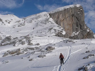
Schiberg (2,044 m a.s.l.)


The Schiberg owes its name to the appearance of the bright limestone. It is the destination of a beautiful, varied tour, with difficult scrambling at the summit.
Ascent / descent
A)Normal route from Innerthal. Difficulty WS
- Ascent / descent: 1125m | Uphill on descent: 0m
- Starting altitude: 906 m.a.s.l. | Target altitude: 2038 m.a.s.l.
- Required ascent time: 3¾ h | Distance: 6.3 km
- Places on the route: Heuboden (Innerthal - SZ) - Oberhof (Innerthal - SZ) - Hohfläschenhütte - Schiberg
Ascent / descent
B) from Innerthal. Difficulty ZS
- Ascent / descent: 1130m | Uphill on descent: 0m
- Starting altitude: 906 m.a.s.l. | Target altitude: 2038 m.a.s.l.
- Required ascent time: 4¼ h | Distance: 6.2 km
- Places on the route: Heuboden (Innerthal - SZ) - Hohfläschenhütte - Tschingel (Innerthal - SZ) - Schiberg
- 3:45 h
- 12.53 km
- 1,110 m
- 1,110 m
- 898 m
- 2,038 m
- 1,140 m
- Start: Innerthal, bus stop
Good to know
Best to visit
Directions
Tour information
Loop Road
Author
Einsiedeln-Ybrig-Zürichsee Tourismus
Organization
Einsiedeln-Ybrig-Zürichsee
Safety guidelines
Avalanche situation:
In case of uncertain snow conditions, we recommend consulting the avalanche bulletin. Every winter sports enthusiast is responsible for themselves and uses the ski tours at their own risk.
Nearby
Download GPX file