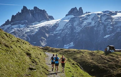
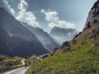
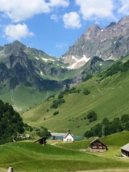
Surenenpass


The hike takes about 6 hours when using the Engelberg-Fürenalp and Attinghausen-Brüsti aerial cableways. A combined ticket is available for both cableways. Generally, the Surenenpass is passable from June to mid/end of October, depending on snow conditions. Please check the current conditions with the Engelberg-Fürenalp or Attinghausen-Brüsti cableways.
Before or after the hike over the Surenenpass, transport between Engelberg and Attinghausen can be booked with the Titlis Taxi Engelberg. Reservations by phone until 10 a.m., price upon request.
- 8:00 h
- 24.11 km
- 704 m
- 2,124 m
- 434 m
- 2,292 m
- 1,858 m
- Start: Engelberg
- Destination: Attinghausen
Waypoints
Good to know
Best to visit
Directions
Directions & Parking facilities
Additional information
Via Alpina
The Surenenpass hike is part of the Via Alpina. The Via Alpina passes through 8 countries and extends over 5000 km in more than 300 day stages. There is a hiking pass for the Via Alpina. This stage can be stamped at the Engelberg Titlis Tourism office.
Detailed description of the route on Schweiz Mobil
Author
Engelberg - Titlis Tourismus
Organization
Engelberg-Titlis Tourismus
Author´s Tip / Recommendation of the author
Attractions on the hike
- Alpine fauna and flora
Enjoy the fresh alpine air and discover a unique variety of alpine flora. With some luck, you can observe wild animals such as chamois, marmots, and ibexes along the hike. A true paradise for nature lovers. - Various mountain huts in summer
Along the route, several mountain huts invite you to stop during the alpine summer. The path also passes by the Surenen cheese dairy. During the alpine season, the herders gladly offer their fresh alpine products and invite you to enjoy a cool drink or a small snack in their mountain huts.
Safety guidelines
Nearby