Titlis valley station-Bänklialp-Gerschnialp-Gerschnialp station


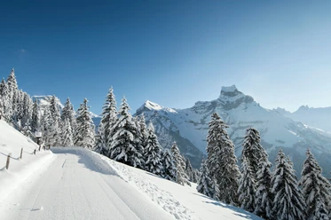
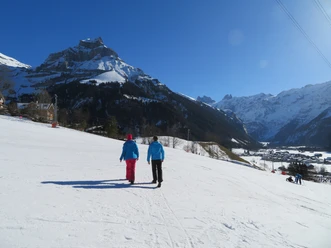
The starting point is the valley station of the TITLIS cable cars. From there, you follow the Engelberger Aa, past the Sportingpark, to the bridge leading to the Hotel & Restaurant Bänklialp. Then continue up the street until a signpost points to the hiking path. Follow the path through a fairytale-like, snow-covered forest. Away from all the hustle, you can relax your soul and enjoy the winter landscape. The hike takes about an hour until you slowly smell the aroma of a hot chocolate. The Gerschnialp restaurant invites you for a hot drink and is a good place for a stop on your route. Once your toes and fingers are warmed, continue for about another fifteen minutes to the Gerschnialp mountain station. Along the ski slopes, you can watch little ski stars trying their first ski attempts. Upon reaching the mountain station, the funicular leads down to Engelberg.
- 1:18 h
- 3.69 km
- 270 m
- 997 m
- 1,267 m
- 270 m
- Start: Titlis valley station
- Destination: Gerschnialp station
Good to know
Best to visit
Directions
Tour information
Familiy-Friendly
Mountain Railway Tour
Equipment
Directions & Parking facilities
National and international connections (from Zurich Airport connections every half hour with about 1 hour travel time) to Lucerne.
Then take the Zentralbahn in 43 minutes through varied landscapes and gorges up to Engelberg. The combination with the boat is also appealing: from Lucerne by lake to Beckenried and from there by public bus and train to Engelberg.
Additional information
Author
Engelberg - Titlis Tourismus
Organization
Engelberg-Titlis Tourismus
Author´s Tip / Recommendation of the author
Safety guidelines
When planning, check the winter sports report on engelberg.ch which indicates whether the winter hiking trails are groomed and open.
Nearby