Waterfall roundcourse

- 0:50 h
- 2.52 km
- 154 m
- 154 m
- 1,764 m
- 1,918 m
- 154 m
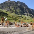
Despite the shortness, the route is not to be underestimated, as the ascent along the Stäubi is rough terrain. Above the waterfall, the Trübseebach stream is crossed in flatter terrain and you return to the starting point on the mountain hiking trail.

Waypoints
Good to know
Pavements
Unknown
Trail
Best to visit
suitable
Depends on weather
Tour information
Loop Road
Equipment
- Festes Schuhwerk wird empfohlen
- Beachten Sie Wetterverhätnisse
Literature
Keine
Author
Engelberg - Titlis Tourismus
Organization
Engelberg-Titlis Tourismus
Author´s Tip / Recommendation of the author
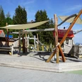
The smugglers' playground at the starting point is a must for every family!
Safety guidelines
- Solid footwear is recommended
- Take note of weather conditions
Map
1191 Engelberg
Nearby