Alpenkranz 11th Stage: Haldi - Bälmeten - Seewlisee


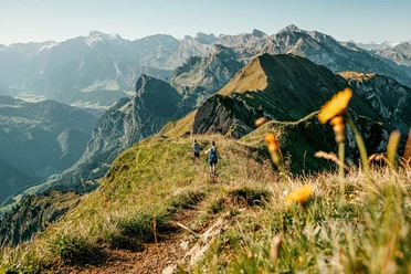
On an easy hiking path, we reach from Haldi (1348 m, near the mountain and ski house Oberfeld) to Ober Oberfeld. Then we follow the hiking path over the rear valley basin to the Pfaffenwald junction (1460 m). Here begins the steep ascent over the Stafel to Butzenboden, accompanied by the unique panoramic view far over Lake Uri and towards the proud backdrop of the Uri mountains. The path continues upward beneath Hoch Fulen up to the saddle Bälmneter Grätli (2252 m). Here, the summit ascent is worthwhile. On the Bälmeten (2415 m) we can enjoy a beautiful picnic with a unique panoramic view.
From Bälmeten, we return to Bälmneter Grätli and turn right downhill towards Stich. There follows a last ascent to Stich, from where we descend via Lang Büel (2201 m) to the Alp uf den Büelen (2031 m). Here, Seewlisee (2026 m) offers a very special ambiance.
- Technical difficulty: T2, white-red-white
- 5:30 h
- 11.39 km
- 1,333 m
- 546 m
- 1,246 m
- 2,413 m
- 1,167 m
- Start: Haldi above Schattdorf
- Destination: Seewlisee, Alp uf den Bielen
Good to know
Pavements
Best to visit
Directions
Tour information
Familiy-Friendly
Nature Highlight
Equipment
- Sturdy hiking boots with grippy soles, weather-appropriate equipment, topographic national maps (not only smartphone), compass, and altimeter are part of the basic equipment.
- Additionally, a first aid kit, emergency blanket, and mobile phone for emergencies belong to the basic equipment.
- Hiking poles are very helpful, especially with a heavy backpack.
Directions & Parking facilities
This stage is possible as a two-day hike with an overnight stay at Seewlisee.
Haldi and Silenen are easily accessible by public transport.
https://www.uri.swiss/de/erleben/seilbahn-eldorado-uri/seilbahn/silenen-chilcherberge/
Additional information
- www.alpenkranz.ch
- Here you can learn everything about the sun terrace Haldi!
- Great routes and experiences with horses and goats, time out with animals on Haldi.
- Accommodation at Seewlisee: the Alp uf den Bielen and the Seewlisee!
Local mountain guides & qualified hiking leaders can be found at; Montanara Mountain Experiences, Mountain Guides Association Uri and Honigberg.ch
Literature
Author
Sanna Laurén
Organization
Verein Urner Wanderwege
Author´s Tip / Recommendation of the author
Tip:
Don't forget your swimwear. But be careful: do not swim too far out (underground outlet)! Passionate fishermen – equipped with the necessary fishing license – try their luck in Seewlisee.
Safety guidelines
Mountain hiking is demanding.
For mountain and alpine hiking trails, knowledge of the dangers in the mountains (rockfall, risk of slipping/falling, sudden weather changes) is necessary. Sturdy hiking boots with grippy soles, weather-appropriate equipment, topographic national maps (not only smartphone), compass, and altimeter are part of the basic equipment. Additionally, a first aid kit, emergency blanket, and mobile phone for emergencies belong to the basic equipment.
It is advisable to carry out a serious route planning and careful preparation for each hike. Weather in the mountains can change very quickly. Fog can also make orientation difficult in summer. The greatest danger in summer besides heat is thunderstorms. Thunderstorms with heavy rain and hail can quickly turn a small stream into large rivers and increase the risk of mudslides and rockfall. Therefore, it is important to interpret the weather forecast during route planning. Warm thunderstorms often come only in the afternoon, but frontal thunderstorms can occur at any time of day. In general, it is worthwhile to start early in summer.
Mountain guides or qualified hiking leaders (up to T4) are recommended for alpine hiking trails (white-blue-white marked route), hiking leaders for hiking and mountain hiking. They take over the organization and planning of the tours so that guests can simply enjoy the hike.
The Uri hiking planner and the Uri Outdoor app help with planning. Via Geo Admin, one can find many useful information such as where pastures with herd protection dogs, suckler cow pastures, and also wildlife resting zones are located.
Hikers hike at their own risk. The association Urner Wanderwege is not liable for accidents occurring during the Urner Alpenkranz hike.
Map
Uri hiking and biking map, sheets Schächental and Maderanertal
The sheets "Schächental" and "Maderanertal" are available in the Uri hiking trails webshop: www.urnerwanderwege.ch/de/shop
Nearby

