Alpenkranz 8th stage: Ratzi - Heidmannegg - Klausenpass


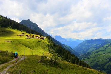
From the mountain guesthouse Ratzi (1511 m), we follow the signpost "Schächentaler Höhenweg" and reach through lightly wooded terrain via Sidenplangg to Äbnet. Impressive is the mighty backdrop of the Uri mountain world: prominently visible above the Reuss valley are Uri Rotstock, Krönten, and Spannort. South of the Schächental, our gaze falls on the Ruchen chain, the dark north faces of the Windgällen.
From Äbnet, the trail climbs to "ob den Hegen." After a further short ascent, we reach under the limestone walls of the Schächentaler Windgällen the huts of Alp Mettenen. Then the route leads past Altstafel further to Heidmannegg (1862 m). There we follow the Schächentaler Höhenweg on a scenic terrace descending slightly to the Balm (1780 m) and reach the well-known Hotel KlausenPasshöhe (1837 m) within a few minutes on foot.
- Technical difficulty: T2, white-red-white
- 4:15 h
- 10.41 km
- 555 m
- 231 m
- 1,513 m
- 1,870 m
- 357 m
- Start: Ratzi
- Destination: Klausenpass
Good to know
Pavements
Best to visit
Directions
Tour information
Familiy-Friendly
Nature Highlight
Equipment
- Sturdy hiking boots with grippy soles, weather-appropriate equipment, topographic national maps (not just smartphone), compass, and altimeter belong to the basic equipment.
- Additionally, basic equipment includes a first aid kit, emergency blanket, and mobile phone for emergencies.
- Hiking poles are very helpful, especially with a heavy backpack.
Directions & Parking facilities
This stage is possible as a day stage:
From Flüelen train station, you can easily reach the valley station of the Spiringen-Ratzi cable car by post bus. Within a few minutes, you are at the starting point of the hike by cable car.
The Hotel Klausenpasshöhe has direct connection to the Altdorf - Linthal post bus line.
Additional information
- www.alpenkranz.ch
- Here you can find all information about the Schächentaler Höhenweg!
- Accommodation at Klausenpass; Hotel Klausenpasshöhe
- You can find experiences in the Uri holiday region here: uri.swiss
Local mountain guides & qualified hiking leaders can be found at; Montanara Bergerlebnisse, Bergführerverein Uri, and Honigberg.ch
Literature
Author
Sanna Laurén
Organization
Verein Urner Wanderwege
Safety guidelines
Mountain hiking is demanding.
For mountain and alpine hiking trails, knowledge of dangers in the mountains (rockfall, slipping/falling hazards, weather changes) is necessary. Sturdy hiking boots with grippy soles, weather-appropriate equipment, topographic national maps (not just smartphone), compass, and altimeter belong to the basic equipment. Additionally, basic equipment includes a first aid kit, emergency blanket, and mobile phone for emergencies.
It is recommended to do serious route planning and careful preparation for every hike. The weather in the mountains can change very quickly. Fog can also make orientation difficult, even in summer. The greatest danger in summer besides heat is thunderstorms. Thunderstorms with heavy rain and hail quickly turn a small brook into large rivers and increase the risk of mudslides and rockfall. Therefore, it is important to interpret the weather report when planning routes. Heat thunderstorms often come only in the afternoon, but frontal thunderstorms can occur at any time of day. Generally, it is worthwhile to be on the move early in summer.
Mountain guides or qualified hiking leaders (up to T4) are recommended for alpine hiking trails (white-blue-white marked route), hiking leaders for hikes and mountain hikes. They take over the organization & planning of routes so that guests can simply enjoy the hike.
The Uri hiking planner and the Uri Outdoor App help with planning. Through Geo Admin, you can find many useful pieces of information, such as where there are pastures with herd protection dogs, mother cow pastures, and also wildlife resting zones.
Hikers hike at their own risk. The Uri hiking trails association is not liable for accidents that occur during the Uri Alpenkranz hike.
Map
Hiking and bike map of the canton of Uri, Schächental sheet
The "Schächental" sheet is available in the Uri hiking trails web shop: www.urnerwanderwege.ch/de/shop
Nearby

