Alpenkranz 37th stage: Sunniggrathütte - Langchälengrätli - Leutschachhütte


The connecting route from Sunniggrathütte (1797 m) to the Leutschachhütte under the mountain range Ruchälplistock - Jakobiger - Chapferplanggenstock leads through a magnificent natural landscape.
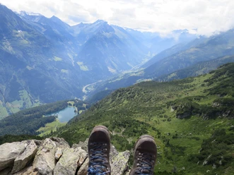
We leave the scenic Sunniggrathütte heading west, hike past charming moor pools and follow the ascending ridge path up to Langchälengrätli (2095 m). Then the path descends passing splendid and diverse alpine flora to the junction Pt. 1948 m. Here we take the upper route to the right past Älpli towards Leutschachhütte. The path continues along the steep mountain slope of Glatt Planggen and in changing ups and downs through rugged rocks. It is well marked and guides us at the steep Chapferplanggen, merged with other routes, about 100 meters north to the Leutschachhütte SAC (2209 m). On this route, there are a few secured key points to overcome.
- Technical difficulty: T3, white-red-white
- 2:30 h
- 5.07 km
- 400 m
- 174 m
- 1,941 m
- 2,222 m
- 281 m
- Start: Sunniggrathütte
- Destination: Leutschachhütte
Good to know
Pavements
Best to visit
Directions
Tour information
Nature Highlight
Equipment
- Sturdy hiking boots with grippy soles, weather-appropriate equipment, topographic national maps (not just smartphone), compass, and altimeter belong to the basic equipment.
- In addition, a pocket first-aid kit, emergency blanket, and mobile phone for emergencies are part of the basic equipment.
- Hiking poles are very helpful, especially with a heavy backpack.
Directions & Parking facilities
This stage is possible as a day hike.
Arrival and/or departure at the mountain station of the Intschi-Arni or Amsteg-Arni cable car. In Intschi direct connection to the bus. In Amsteg connection to the bus combined with a 15-minute walk.
Additional information
- www.alpenkranz.ch
- Accommodation for stage 37; Leutschachhütte
- Experiences in the Uri holiday region can be found here: uri.swiss
- Local mountain guides & qualified hiking leaders can be found at; Montanara Bergerlebnisse, Bergführerverein Uri and Honigberg.ch.
Literature
Author
Sanna Laurén
Organization
Verein Urner Wanderwege
Author´s Tip / Recommendation of the author
Tip:
Below the hut is the exceptionally dark blue Nidersee, which depending on the incidence of light also presents itself in the most beautiful turquoise blue. The Obersee is also well suited for relaxing and is perfect for a refreshing dip.
Option:
There is an easier but considerably longer variant available. It leads at the signpost at point 1948 m on a good path directly down into the Leutschach Valley basin towards Alpstafel Furt. From there we hike the hut trail up over the Nidersee to the Leutschachhütte.
Safety guidelines
Mountain hiking is demanding.
Knowledge of dangers in the mountains (rockfall, slip/fall hazard, sudden weather changes) is necessary for mountain and alpine hiking trails. Sturdy hiking boots with grippy soles, weather-appropriate equipment, topographic national maps (not just smartphone), compass, and altimeter belong to the basic equipment. Additionally, a pocket first-aid kit, emergency blanket, and mobile phone for emergencies are part of the basic equipment.
It is advisable to do serious route planning and careful preparation for every hike. The weather in the mountains can change very quickly. Fog can make orientation difficult even in summer. The greatest danger in summer besides heat are thunderstorms. Thunderstorms with heavy rain and hail quickly turn small streams into large rivers, and the risk of mudflows and rockfall increases. Therefore, it is important to interpret the weather report when planning tours. Heat thunderstorms often come only in the afternoon, but frontal thunderstorms can occur at any time of day. In general, it is worthwhile to be on the move early in the summer.
Mountain guides or qualified hiking leaders (up to T4) are recommended for alpine hiking trails (white-blue-white marked routes), hiking leaders for hikes and mountain hikes. They take over the organization and planning of tours so that guests can simply enjoy the hike.
The Uri hiking planner and the Uri Outdoor app help with planning. Via Geo Admin you can find many useful information such as where pastures with guardian dogs, suckler cow pastures and also wildlife protection zones are located.
Hikers hike at their own responsibility. The Uri hiking trails association is not liable for accidents that occur during the Uri Alpenkranz hike.
Map
Hiking and biking map of the canton of Uri, Maderanertal sheet.
The "Maderanertal" sheet is available in the Uri hiking trails web shop: www.urnerwanderwege.ch/de/shop
Nearby

