Alpenkranz 38th Stage: Leutschach Hut - Leidsee - Krönten Hut


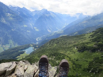
From the Leutschach Hut SAC (2209 m), the ascent leads under the Ruchen to the rock spur of the Chapferplanggenstock. Then safety ropes ease the way through rugged grassy slopes interspersed with rocks and cut rock channels to the ridge west of the lowest saddle, the highest point of this stage at 2407 m. A fascinating view into the mountain landscape shaped by the Alpine folding compensates us for the effort of the ascent. Over the gentle connecting ridge, the route leads us further down to the Leidsee Pass (2328 m). After the mid-morning break on the shore above the dark, legendary Leidsee, the path follows the foot of the Jakobiger to Riedfurggi (2213 m). Now we turn westwards and descend a few switchbacks down to Unter Älpli. From there, we ascend westwards on the left into the steeply inclined northeast flank of the Hundtschingel. After crossing the flank, which is secured with chains and wire ropes in two places, the panoramic path meets at point 1969 m the marked hiking trail leading from Bodenberge over Päuggenegg. At the large wooden cross, we enjoy the dreamlike scenery. The descent takes us over extensive moorlands with diverse plant life, past gneiss boulders at the climbing garden to the hospitable Krönten Hut SAC (1903 m).
- Technical difficulty: T4, white-blue-white
- 3:30 h
- 5.74 km
- 329 m
- 635 m
- 1,903 m
- 2,407 m
- 504 m
- Start: Leutschach Hut
- Destination: Krönten Hut
Good to know
Pavements
Best to visit
Directions
Tour information
Nature Highlight
Equipment
- Sturdy hiking boots with grippy soles, weather-appropriate equipment, topographic national maps (not just smartphone), compass, and altimeter are part of the basic equipment.
- Additionally, a small first aid kit, emergency blanket, and mobile phone for emergencies belong to the basic equipment.
- Trekking poles are very helpful, especially with a heavy backpack.
- For alpine hiking trails, depending on the stage, rope, climbing harnesses, ice axe, and crampons are also recommended.
Directions & Parking facilities
This stage can be done as a 2-day stage with an overnight stay at the Leutschach or Krönten Hut.
Arni and Erstfeld are well accessible by public transport. There is a taxi service from Erstfeld to Bodenberge.
Alpentaxi Näf Tel. 079 413 91 15
UWE's Taxi Tel. 077 437 71 61
Arrival and/or departure via the cable car station Intschi-Arni or via Erstfeld train station and taxi to Bodenberge.
https://www.sac-gotthard.ch/kroentenhuette/lage-und-erreichbarkeit/
Additional information
- www.alpenkranz.ch
- Accommodation for stage 38; Krönten Hut
- Experiences in the Uri holiday region can be found here: uri.swiss
- Local mountain guides & qualified hiking leaders can be found at; Montanara Bergerlebnisse, Mountain Guide Association Uri and Honigberg.ch.
Literature
Author
Sanna Laurén
Organization
Verein Urner Wanderwege
Author´s Tip / Recommendation of the author
Tip:
- The route is demanding and suitable only for experienced mountain hikers.
- After the hike, a swim at pleasant water temperature awaits below the Krönten Hut in the Fulensee high moor area.
Option:
The shorter variant leads as a white-blue-white marked alpine route between Sunnig and Mäntliser through a wild rocky landscape up to the narrow rock gate of Steinchelenfurggi (Ruch Pass).
Safety guidelines
Mountain hiking is demanding.
Knowledge of mountain hazards (rockfall, slip/fall danger, weather changes) is necessary for mountain and alpine hiking trails. Sturdy hiking boots with gripping soles, weather-appropriate equipment, topographic national maps (not just smartphone), compass, and altimeter belong to the basic equipment. Additionally, a small first aid kit, emergency blanket, and mobile phone for emergencies belong to the basic equipment.
It is advisable to carry out serious route planning and careful preparation for every hike. The weather in the mountains can change very quickly. Fog can make orientation difficult even in summer. The greatest danger in summer besides the heat is thunderstorms. Thunderstorms with heavy rain and hail can quickly turn a small brook into large streams and increase the danger of mudslides and rockfalls. Therefore, it is important to interpret the weather report when planning routes. Heat thunderstorms usually come only in the afternoon, but frontal thunderstorms can occur at any time of the day. In general, it is worth starting early in summer.
Mountain guides or qualified hiking leaders (up to T4) are recommended for alpine paths (white-blue-white marked routes), hiking leaders for hikes and mountain hikes. They take over the organization and planning of the tours so that guests can simply enjoy the hike.
The Uri hiking planner and the Uri Outdoor App help with planning. Via Geo Admin, many useful information can be found, such as where pastures with herd protection dogs, suckler cow pastures, and also wildlife quiet zones are located.
Hikers hike at their own risk. The Uri hiking trails association does not accept liability for accidents that occur during the Uri Alpenkranz hike.
Warning: The route is demanding and suitable only for experienced mountain hikers.
Map
Hiking and biking map of the canton of Uri, Maderanertal sheet.
The sheet "Maderanertal" is available in the Uri hiking trails web shop: www.urnerwanderwege.ch/de/shop
Nearby

