Alpenkranz 4th stage: Musenalp - Bärchi - Eggbergen


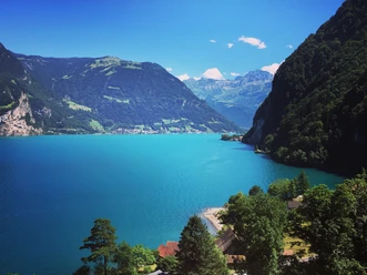
The impressive panoramic view of the Isenthal mountain world accompanies us on the way from Musenalp (1483 m) down into the Chlital. First across alpine pastures, then through open spruce forest and partly accompanied by the Chlitaler stream, we reach over Chlosterberg - Chli Bergli the Isenthal village.
At the exit of the village, follow the hiking path ascending left via Heissrüti over Hinterbärchi to the fantastic viewpoint Hinterbärchi (890 m). Above Lake Uri shines the summit cross of Rophaien, behind the valley basin of Schwyz greet the Mythen mountains, and the Uri mountain landscape presents itself like a relief. The old country road into the Uri region now leads in switchbacks downhill and guides us through beech forests further to the palms of the picturesque lakeside community Bauen (435 m).
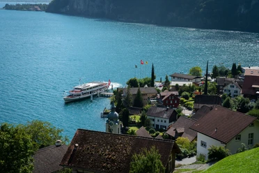
With the ship of the SGV, we "steam" on a nostalgic ride to the harbor town Flüelen and reach over the old village center after 10 minutes the Moosbad and the valley station of the air cableway Flüelen– Eggberge (1447 m). After a scenic cable car ride to the Eggbergen (1447 m), the mountain inn Eggberge awaits us.
- Technical difficulty level: T2, white-red-white
- 3:55 h
- 9.72 km
- 199 m
- 1,248 m
- 434 m
- 1,490 m
- 1,056 m
- Start: Musenalp, Isenthal
- Destination: Air cableway Flüelen - Eggberge
Good to know
Pavements
Best to visit
Directions
Musenalp - Chlital - Isenthal village - Hinterbärchi - Bauen – (Isleten - Seedorf - Reussdelta ) - Flüelen - valley station air cableway Flüelen - Eggberge
Tour information
Familiy-Friendly
Mountain Railway Tour
Nature Highlight
Stop at an Inn
Equipment
- Sturdy hiking shoes with a grippy sole, weather-appropriate equipment, topographic national maps (not only a smartphone), compass and altimeter belong to the basic equipment.
- Additionally, a first aid kit, emergency blanket and mobile phone for emergencies are part of the basic equipment.
- Hiking poles are very helpful, especially with a heavy backpack.
Directions & Parking facilities
This stage is possible as a day hike.
Isenthal and Eggberge are both easily accessible by public transport.
You start in Isenthal village, where you can easily reach by public transport. Then you continue hiking as described in the route to Bauen and by boat to Flüelen and can start your journey home or onward from Flüelen.
www.uri.swiss/de/erleben/seilbahn-eldorado-uri/seilbahn/chlital-musenalp/
Additional information
- www.alpenkranz.ch
- There is accommodation on the Eggberge;
Local mountain guides & qualified hiking leaders can be found at; Montanara Bergerlebnisse, Mountain Guide Association Uri and Honigberg.ch
Information about the Uri experience region can be found here: www.uri.swiss
Book your accommodation in the Uri experience region: www.uri.swiss/de/planen/unterkuenfte/
Literature
Author
Sanna Laurén
Organization
Verein Urner Wanderwege
Author´s Tip / Recommendation of the author
Tip:
The ride with the cable car from Musenalp down to the valley into Chlital is a delight. Also, take your swimwear with you! On this stage, there are nice swimming opportunities to discover.
Option:
Those who want to skip the boat can hike on foot along the "Path of Switzerland" by Lake Uri towards Isleten - Seedorf - Flüelen to the valley station of the air cableway Flüelen – Eggberge.
Safety guidelines
Mountain hiking is demanding. For mountain hiking trails, knowledge of hazards in the mountains (rockfall, slip/fall hazard, sudden weather changes) is necessary. Sturdy hiking shoes with a grippy sole, weather-appropriate equipment, topographic national maps (not only smartphone), compass and altimeter belong to the basic equipment. Additionally, a first aid kit, emergency blanket and mobile phone for emergencies belong to the basic equipment.
It is recommended to do serious route planning and careful preparation for each hike. The weather in the mountains can change very quickly. Fog can also make orientation difficult even in summer. The greatest danger in summer besides heat are thunderstorms. Thunderstorms with heavy rain and hail can quickly turn a small stream into large rivers and increase the risk of mudflows and rockfalls. Therefore, it is important to interpret the weather report when planning the route. Heat thunderstorms often occur only in the afternoon, but frontal thunderstorms can occur at any time of day. In general, it is worth starting early in summer.
Mountain guides or qualified hiking leaders (up to T4) are recommended for alpine hiking trails (white-blue-white marked route), hiking leaders for hikes and mountain hikes. They take over the organization & planning of the tours so that guests can simply enjoy the hike.
The Uri hiking planner and the Uri Outdoor app help with the planning. Via Geo Admin, you find many useful information, such as where pastures with herd protection dogs, mother cow pastures and also wild animal resting zones are located.
Hikers hike at their own risk. The Uri Hiking Trails association is not liable for accidents that occur during the Uri Alpenkranz hiking tour.
Map
Hiking and bike map of the Canton of Uri, Urnersee sheet
The "Urnersee" sheet is available in the Urner hiking trails webshop: www.urnerwanderwege.ch/de/shop
Nearby


