Alpenkranz 3rd stage: Biwaldalp - Sassigrat - Musenalp


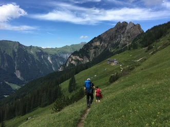
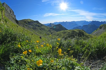
From the tourist restaurant Biwaldalp (1695 m), we follow a good path and first pass between large boulders and over alpine pastures with a varied plant world, ascending slightly to the lowest notch of the Sassigrat pass (1868 m). At the same time, we change from the Isenthaler main valley over to the Kleintal. In the federal game reserve, we can, with a little luck, observe whole groups of chamois. Next to the Schartihöreli, the view is open up to the Urner See towards Sisikon and the nearby mountains Gitschen, Schlieren, and the Uri-Rotstock, which impress with their size and beauty. In the distance, the Mythen, Rophaien, Schächentaler Windgällen, and Glärnisch also greet us.
From the Sassigrat, we descend steeply over the east side of the almost treeless mountain flank through colorful flora to Äbnet and pass above the Musenalp through some wet sections, where besides grass frogs, the corresponding plant life is also present.
Then we continue hiking through a botanically very interesting slope to the mountain guesthouse Musenalp (1483 m).
- Technical difficulty: T2, white-red-white
- 1:10 h
- 2.33 km
- 173 m
- 379 m
- 1,493 m
- 1,868 m
- 375 m
- Start: Biwaldalp, Isenthal
- Destination: Musenalp, Isenthal
Good to know
Pavements
Best to visit
Directions
Tour information
Familiy-Friendly
Stop at an Inn
Equipment
- Sturdy hiking boots with a grippy sole, weather-appropriate equipment, topographic national maps (not just a smartphone), compass, and altimeter belong to the basic equipment.
- Additionally, a first aid kit, emergency blanket, and mobile phone for emergencies are part of the basic equipment.
- Hiking poles are very helpful, especially with a heavy backpack.
- For alpine hiking trails, depending on the stage, rope, climbing harnesses, ice axe, and crampons are additionally recommended.
Directions & Parking facilities
This hike is possible as a day stage.
Isenthal is well accessible by public transport.
Travel by public transport to Isenthal St. Jakob. From there, hike to Biwaldalp, where the 2nd stage ends. You continue along the Alpenkranz route to the Musenalp, where the 3rd stage ends. From there, it is best to take the Musenalp-Kleintal cable car. Once down, there is still about a 1-hour walk to Isenthal village, where you can travel home or further by public transport.
www.bergrestaurant-musenalp.com/anreise
www.uri.swiss/de/erleben/seilbahn-eldorado-uri/seilbahn/chlital-musenalp
Additional information
- www.alpenkranz.ch
- Accommodation for stage 3; Mountain restaurant Musenalp
Local mountain guides and qualified hiking leaders can be found at: Montanara Bergerlebnisse, Mountain Guide Association Uri, and Honigberg.ch
Information about the Uri adventure region can be found here: www.uri.swiss
Book your accommodation in the Uri adventure region: www.uri.swiss/de/planen/unterkuenfte/
Literature
Author
Sanna Laurén
Organization
Verein Urner Wanderwege
Author´s Tip / Recommendation of the author
Tip:
Take your time for this stage and enjoy the stay and the atmosphere at the Biwaldalp and on the Musenalp.
Option:
The Musenalp is also the starting point for the ascent to Uri-Rotstock (2928 m, T4). At about 2000 m, the path to Gitschen (2513 m, T5) branches off. Both routes are very steep and marked as alpine routes with white-blue-white signs.
Safety guidelines
Mountain hiking is demanding. For mountain and alpine hiking trails, knowledge of the dangers in the mountains (rockfall, slip/fall hazard, sudden weather changes) is necessary. Sturdy hiking boots with a grippy sole, weather-appropriate equipment, topographic national maps (not just a smartphone), compass, and altimeter belong to the basic equipment. For alpine hiking trails, rope, ice axe, and possibly crampons are additionally recommended. Additionally, a first aid kit, emergency blanket, and mobile phone for emergencies form part of the basic equipment.
It is advisable to have serious route planning and careful preparation for every hike. The weather in the mountains can change very quickly. Fog can make orientation difficult even in summer. The greatest danger in summer besides the heat is thunderstorms. Thunderstorms with heavy rain and hail can quickly turn a small brook into large rivers and increase the risk of mudslides and rockfall. Therefore, it is important to interpret the weather report during route planning. Heat thunderstorms often come only in the afternoon, but front thunderstorms can occur at any time of the day. In general, it is worth being on the move early in summer.
Mountain guides or qualified hiking leaders (up to T4) are recommended for alpine hiking trails (marked white-blue-white routes), hiking leaders for hikes and mountain hikes. They take over the organization and planning of tours so that guests can simply enjoy the hike.
The Uri hiking planner and the Uri Outdoor app help with planning. Via Geo Admin, you can find many useful information, such as where grazing areas with herd protection dogs, suckler cow pastures, and also wildlife resting zones are located.
Hikers hike at their own risk. The association Urner Wanderwege is not liable for accidents that occur during the Urner Alpenkranz hike.
Map
Hiking and biking map of the canton of Uri, sheet Urnersee
The sheet "Urnersee" is available in the web shop of the Uri hiking trails: www.urnerwanderwege.ch/de/shop
Nearby
