Alpenkranz 5th stage: Eggberge - Schön Chulm - Lidernenhütte


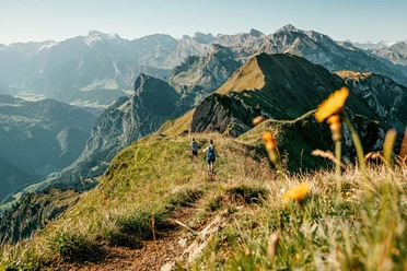
On the Eggberge (1447 m), we enjoy the wonderful mountain panorama and the wide view into the Pre-Alps, then follow the service road up to Angelingen Kreuzegg. At this fork, the route climbs to the well-visible mountain cross and leads us further through the lightly forested nature reserve to Hüenderegg (1873 m). On a gently descending path, we reach in a hollow the popular Fleschseeli and then hike to Chalberweid, from where the path leads up to the forest edge and continues to Schön Chulm (2022 m). The landscape change shows the contrasts between the steeply rising Rossstock, past Siwfass and Hagelstock to the highest point at 2140 m and the softness of the Pre-Alps with views to Spilauer Seeli. After a lengthy lunch break, we walk down over alpine pastures into the hollow to Spilauer Seeli and enjoy a cool drink half an hour later in the cozy Lidernenhütte SAC (1727 m).
- Technical difficulty: T2, white-red-white
- 4:00 h
- 8.82 km
- 769 m
- 479 m
- 1,440 m
- 2,140 m
- 700 m
- Start: Eggberge
- Destination: Lidernenhütte
Good to know
Pavements
Best to visit
Directions
Tour information
Mountain Railway Tour
Nature Highlight
Stop at an Inn
Equipment
- Sturdy hiking boots with good grip soles, weather-appropriate equipment, topographical maps (not just smartphone), compass and altimeter belong to the basic equipment.
- Additionally, basic equipment also includes a pocket first aid kit, rescue blanket, and mobile phone for emergencies.
- Hiking poles are very helpful, especially with a heavy backpack.
Directions & Parking facilities
This stage is also possible as a day stage:
The bus from Flüelen train station makes the valley station of the Flüelen-Eggberge aerial cableway easily accessible.
The valley station of the Käppeliberg-Spilau cable car is also well accessible by bus from Sisikon station. However, the bus requires a reservation:
Bus Käppeliberg - Sisikon or return 041 820 32 55/079 249 47 02
Additional information
- www.alpenkranz.ch
- Accommodation for stage 5; Lidernenhütte
- Experiences in the Uri holiday region can be found here: uri.swiss
Local mountain guides & qualified hiking leaders can be found at; Montanara Bergerlebnisse, Bergführerverein Uri and Honigberg.ch
Literature
Author
Sanna Laurén
Organization
Verein Urner Wanderwege
Author´s Tip / Recommendation of the author
Tip:
Enjoy the unique variety of flowers on the way to Schön Chulm. The sunset at Lidernenhütte – a day hardly could end more beautifully.
Safety guidelines
Mountain hiking is demanding. For mountain hiking trails, knowledge of dangers in the mountains (rockfall, slipping/falling hazards, sudden weather changes) is necessary.
Sturdy hiking boots with grippy soles, weather-appropriate equipment, topographic maps (not only smartphone), compass, and altimeter belong to the basic equipment. Additionally, a pocket first aid kit, rescue blanket, and mobile phone for emergencies are part of the basic equipment.
It is recommended to plan seriously and prepare carefully for every hike. The weather in the mountains can change very quickly. Fog can also make orientation difficult in summer. The biggest danger in summer besides heat are thunderstorms. Thunderstorms with heavy rain and hail can quickly turn a small stream into large rivers and increase the risk of mudslides and rockfall. Therefore, it is important to interpret the weather forecast when planning hikes. Warm thunderstorms often come in the afternoon, but frontal thunderstorms can occur at any time of the day. In general, it is worthwhile to start early in summer.
Mountain guides or qualified hiking leaders (up to T4) are recommended for alpine hiking trails (white-blue-white marked route), hiking leaders for hikes and mountain hikes. They take over the organization and planning of the tours so that guests can simply enjoy the hike.
The Urner Wanderplaner and the Uri Outdoor App help with planning. Through Geo Admin, one finds many useful information such as where pastures with herd protection dogs, mother cow pastures, and also wildlife resting zones are located.
Hikers hike at their own risk. The Urner Wanderwege Association is not liable for accidents that occur during the Urner Alpenkranz hike.
Map
Hiking and biking map of the canton of Uri, Lake Uri sheet
The "Lake Uri" sheet is available in the web shop of Urner Wanderwege: www.urnerwanderwege.ch/de/shop

Nearby
