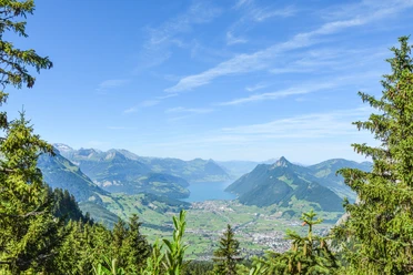
Around the Great Mythen


Discover the wild chamois in the oldest game reserve in Switzerland, the "Mythenbann." First, take the Rotenfluebahn from Rickenbach to the middle station at Rätigs. In Rätigs, the hike begins via Hasli over the sheep pasture and through the forest to Günterigs, where on the right side a steep ascent begins on a well-developed hiking trail through forest sections and over scree. During the ascent to the viewpoint Zwischet Mythen, about 300 meters of elevation is overcome in a short distance. Now begins the more relaxing part of the hike, where the chamois are most frequently seen. Through the most beautiful natural and floral splendor, continue via Alp Zwischet Mythen to Holzegg. With a bit of luck, you might observe a marmot family here. From Holzegg, a final ascent to the Rotenflue awaits you before the Rotenfluebahn takes you back down to the valley. Those who want to hike back to Rickenbach on foot turn off from Holzegg towards Rätigs. The return path via Rätigs-Huserenberg takes about 1.5 hours from Holzegg.
Variant 2
By gondola or on foot from Rickenbach/SZ to the middle station Rätigs, further via Hasli-Günterigs-Zwischet Mythen-Alp Zwischet Mythen-Holzegg-Rotenflue-back to Rickenbach by gondola. Here you find the hiking map.
Distance
6 km
Hiking time
2 h 30 min*
Difficulty
medium
Condition
medium
Elevation gain
682 meters from Rätigs
Variant 3
By gondola from Rickenbach to Rotenflue. From there on foot via Holzegg-Alp Zwischet Mythen to the viewpoint Zwischet Mythen and back the same way. Here you find the hiking map.
Distance
6 km
Hiking time
2 h
Difficulty
easy
Condition
easy
Elevation gain
311 meters
*Hiking time from starting point Rätigs, middle station Rotenfluebahn. Starting in Rickenbach extends the total hiking time by about one hour compared to the stated time.
- 2:30 h
- 6.29 km
- 651 m
- 137 m
- 1,054 m
- 1,571 m
- 517 m
- Start: Valley station Rotenfluebahn Rickenbach
- Destination: Valley station Rotenfluebahn Rickenbach
Good to know
Pavements
Best to visit
Directions
Rätigs-Zwischet Mythen-Rotenflue-Schwyz
Tour information
Loop Road
Mountain Railway Tour
Stop at an Inn
Equipment
Hiking shoes with good tread or trekking shoes, rain jacket, drink, provisions, possibly poles.
Directions & Parking facilities
Drive on the A4 motorway to the Seewen/Schwyz exit. From there, continue via Schwyz to Rickenbach at the valley station of the Rotenfluebahn or to Ibergeregg.
From Zurich, you reach the Mythen region via the A3 motorway to the Einsiedeln exit. From Einsiedeln, continue to Brunni-Alpthal.
Author
Erlebnisregion Mythen
Organization
Schwyzer Wanderwege
Safety guidelines
*Hiking time starting from Rätigs, middle station Rotenfluebahn. Starting in Rickenbach extends the total hiking time by about one hour compared to the stated time.

Nearby


Download GPX file