Badushütte SAC (via Pazolastock - Tomasee)


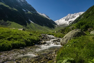
The Badushütte is located near the source of the Rhine at 2500 m above sea level. It is the ideal starting point for various circular hikes and summit destinations in the area. The climbing garden at Fil Tuma is only five minutes from the hut.
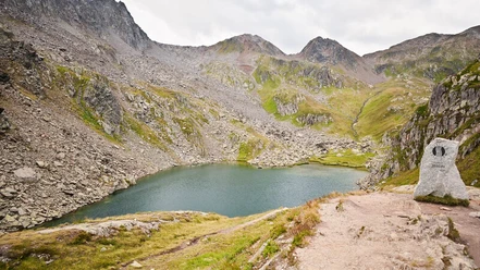
The ascent starts at the Oberalppass station on a well-marked path towards Pazolastock. On the way, you get a fantastic view of the Survela, the mountains around the Gütsch, as well as the Urserntal. The last section leads along a narrow path on the ridge to the summit. There, hikers are rewarded with a wonderful panoramic view. From Pazolastock, it then continues down to the Badushütte, which invites you to take a break. From the Badushütte, you continue walking through the idyllic landscape to the Rhine source at Tomasee. A cooling dip in the fresh spring water gives the final energy boost for the last stage of the hike back to Oberalppass.
- 4:00 h
- 10.09 km
- 806 m
- 806 m
- 1,981 m
- 2,740 m
- 759 m
- Start: Oberalppass station
- Destination: Oberalppass station
Good to know
Pavements
Best to visit
Directions
Tour information
Loop Road
Nature Highlight
Stop at an Inn
Summit
Tour with Dog
Equipment
- Clothing suitable for the weather
- Good footwear
- Hiking poles are recommended
- Binoculars
- Camera
- Day backpack
Directions & Parking facilities
Hikers can reach the starting point by car via the Oberalppass road from Andermatt or Sedrun.
There is a large car park directly at the pass height. Alternatively, there are also some parking spaces along the Oberalppass road.
Hikers can reach the Oberalppass by train from Andermatt or Sedrun. The timetable is as follows: Matterhorn Gotthard Bahn timetable
Additional information
Author
Andermatt-Urserntal Tourismus GmbH
Organization
Région de vacances Andermatt
Author´s Tip / Recommendation of the author
- Tomasee (source of the Rhine) beautiful resting place
- Pazolastock (scenic)
- Lighthouse on the Oberalppass
Safety guidelines
- Hikers should check the weather forecast in advance, as the hike is at an altitude of over 2000 m above sea level and there may be light snowfall in extreme cases.
- Pay attention to weather forecasts. In the Alps, weather can change rapidly.

Nearby

Download GPX file