Tomasee


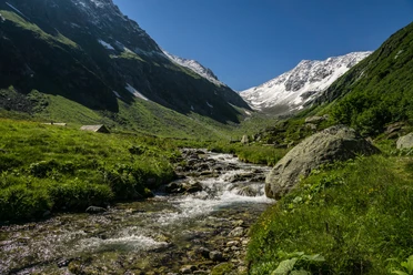
From the Oberalp Pass, the hiking trail initially leads towards Tschamut across alpine pastures with beautiful flora into the Maighel Valley. A narrow mountain path finally leads to the source of the Rhine. The idyllic Tomasee is beautifully embedded in a large basin surrounded by an impressive mountain backdrop. Here, the water begins its 1230 km long journey to the mouth of the sea near Rotterdam. The Rhine then flows through the canton of Graubünden and up to the Rhine Falls in Schaffhausen. From there, the Rhine then runs via Basel through Germany into the sea in Holland.
The same path is taken back to the Oberalp Pass.
- 3:20 h
- 8.88 km
- 459 m
- 459 m
- 1,981 m
- 2,345 m
- 364 m
- Start: Oberalp Pass Station
- Destination: Oberalp Pass Station
Good to know
Pavements
Best to visit
Directions
Tour information
Loop Road
Nature Highlight
Stop at an Inn
Tour with Dog
Equipment
- Weather-appropriate clothing
- Good footwear
- Trekking poles are recommended
Directions & Parking facilities
Hikers can reach the starting point by car via the Oberalp Pass from Andermatt or Sedrun.
Parking spaces are available directly at the starting point Oberalp Pass station of the hike
Hikers reach the Oberalp Pass by train from Andermatt or Sedrun. The timetable is as follows: Matterhorn Gotthard Bahn
Additional information
Author
Andermatt-Urserntal Tourismus GmbH
Organization
Région de vacances Andermatt
Author´s Tip / Recommendation of the author
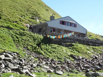
- Short ascent to the Badushütte (approx. 30 minutes)
- Four-Sources-Route
- Lighthouse on the Oberalp Pass
- Cable car
- Alternative: Pazolastock
Safety guidelines
Hikers should watch the weather forecast in advance, as parts of the hike are above 2000 m.a.s.l. and in extreme cases, there can be light snowfall.

Nearby

Download GPX file