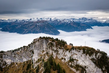
Bützi - Stockflue


Locally, the distinctive rock tower in the mountain forest is called the "thumb" because of its shape. On the topographic map, however, it is called Stockflue and is the destination of a popular short alpine route above Lake Lucerne. Beautiful sections in the bright pine forest alternate with challenging rock passages, some equipped with fixed ropes and metal steps. Inexperienced hikers and children can be secured here with a rope. A final steep ascent leads along ladders and wire ropes to the summit of Stockflue with its phenomenal view over Lake Uri. Those who do not want to use the nearby small cable car preferably choose the leisurely descent via Schränggigen.
- 3:50 h
- 8.46 km
- 700 m
- 700 m
- 437 m
- 1,137 m
- 700 m
- Start: Brunnen station
- Destination: Brunnen station
Good to know
Pavements
Best to visit
Tour information
Loop Road
Mountain Railway Tour
Nature Highlight
Stop at an Inn
Summit
Equipment
Hiking shoes with good tread or trekking shoes, rain jacket, drink, provisions, possibly poles.
Directions & Parking facilities
From the Brunnen motorway exit towards Lake Brunnen, turn left before the station roundabout to Brunnen station.
Ample parking spaces available at the station.
By train to Brunnen station.
Literature
Further information can be found on the SAC tour portal (https://www.sac-cas.ch/de/huetten-und-touren/sac-tourenportal/stockflue-8937/berg-und-alpinwandern/).
Author
Xaver Büeler
Organization
Schwyz Tourismus
Author´s Tip / Recommendation of the author
A visit to the nearby mountain restaurant Timpel is worthwhile even if you do not choose the cable car for the descent. The view from the terrace is hard to beat!

Nearby


Download GPX file