Circular hike Altbüron - Melchnau


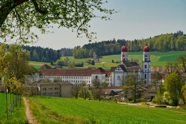
The hike starts north at the exit of Altbüron at a parking lot with a fountain and seating. Accompanied by the babbling of the Rot, it goes along pleasant paths through fields and trees heading north. We repeatedly see the small dams typical of the Wässermatten, called “Brütschen.” At a cozy bridge, there is the opportunity to refresh your feet in the stream. After about 30 minutes, Melchnau is already in sight. It is evident by the stately houses that we are now hiking on Bernese soil. We cross the village and turn into the forest towards the castle ruin just before the church. After a short and steep section, the first wall remains come into view. Information boards explain the history of this castle; a barbecue area is also available. The route continues through the beautiful forest to the Ischerhubel. From there, the path follows the border trail downward back to the Wässermatten.
- 1:45 h
- 6.75 km
- 115 m
- 114 m
- 500 m
- 614 m
- 114 m
- Start: Altbüron
- Destination: Altbüron
Good to know
Best to visit
Directions
The circular route is well signposted
Tour information
Cultural Interesting
Loop Road
Stop at an Inn
Equipment
- Weather-appropriate clothing
- Good footwear
- Hiking poles are recommended
- Camera
- Day backpack
Directions & Parking facilities
Altbüron is located between St. Urban and Zell
Free parking spaces are available
By bus to the Altbüron Halde stop
Additional information
Further information about nature experiences on the circular route and the Wässermatten can be found at the Lebendiges Rottal Association.
Author
Willisau Tourismus
Organization
Willisau Tourismus
Author´s Tip / Recommendation of the author
- Wässermatten
- The church in Melchnau with the charming wooden storehouse
- Barbecue area at the ruin of Grünenberg
Nearby
Download GPX file