Circular hike Gettnau – Ohmstal


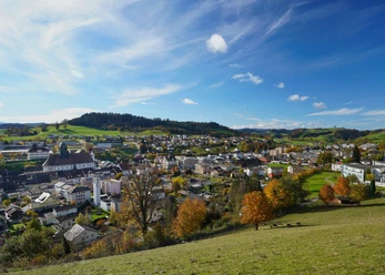
From Gettnau, we follow the Luthern for a short stretch before going steeply uphill through a forest towards Ohmstal. Already, there are first beautiful distant views, and we also spot the Kurhaus Ohmstal with its orange shutters. The small detour to the cozy restaurant is worth it, and freshly strengthened, the route continues over hills and fields towards Gallis up to Hünkihof. From there, there are various options to return to Gettnau. One nice variant first leads towards Zell, at the Bründlen farm the path turns towards Gettnau.
- 3:35 h
- 12.77 km
- 240 m
- 240 m
- 528 m
- 742 m
- 214 m
- Start: Gettnau train station
- Destination: Gettnau train station
Good to know
Pavements
- Street (9%)Asphalt (28%)Trail (33%)Path (30%)
Best to visit
- suitableDepends on weather
Directions
Gettnau - Niderwil - Kleinlörzigen - (Ohmstal for restaurant visit) - Gallis - Hünkihof - follow signposts towards Zell - Gettnau
Tour information
Circular trail
Refreshment stop
Equipment
- Clothing appropriate for the weather
- Good footwear
- Walking poles are recommended
- Daypack
Directions & Parking facilities
- ParkingPaid parking at the station.Public transportationBy BLS to Gettnau
Additional information
The path is not marked as a winter hiking trail
Author
Willisau Tourismus
Organization
Willisau Tourismus
Author´s Tip / Recommendation of the author
- The route can be customized as desired. Depending on the ground conditions and weather, you can walk more along the road (there is very little traffic) or spontaneously take a shortcut.
Map
- Hiking map Swisstopo 234 T
Nearby



Download GPX file