Circular hike Luthern - Heuberg - Nesslisbode


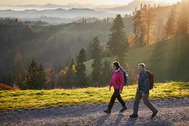
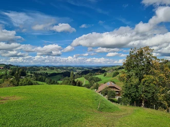
The hike starts in the idyllic village of Luthern and leads us always uphill, past the Heuberg chapel, over fields and through forest. We constantly follow the signpost to "Ahorn" and after Ober Wernisegg we can already see the mountain restaurant Ahorn Alp in the distance. After a last ascent we reach the ridge, which is also crossed by the Napfbergland border path. A short detour to Ahorn Alp is worthwhile (note opening hours beforehand).
We then follow the path towards Napf until the junction to Nesslisbode, where we begin the descent. At Nesslisbode we enjoy the pretty black-nosed sheep and other animals. The path continues over wide gravel roads until Luthern is soon visible again. Tired and satisfied, we make our way home again, not before having treated ourselves to a refreshment at the restaurant Krone.
- 3:20 h
- 10.86 km
- 372 m
- 371 m
- 769 m
- 1,141 m
- 372 m
- Start: Luthern village
- Destination: Luthern village
Good to know
Best to visit
Directions
Luthern - Heuberg Chapel - Ober Wernisegg - Nesslisboden - Luthern
Tour information
Loop Road
Stop at an Inn
Tour with Dog
Equipment
- Weather-appropriate clothing
- Good footwear
- Hiking poles are recommended
- Camera
- Daypack
Directions & Parking facilities
Additional information
Author
Willisau Tourismus
Organization
Willisau Tourismus
Author´s Tip / Recommendation of the author
- Mountain restaurant Ahorn Alp (closed Monday and Tuesday)
- Inn Krone Luthern (closed Wednesday)
- Information for dog owners: mostly in the forest, drinking opportunities after about half of the hike (bring water), Robidog in the village of Luthern and on the ridge towards Ahorn Alp, depending on the season some pasture crossings but always manageable with consideration and small detours, no problems known with farm dogs either.
Nearby

Download GPX file