Cycling route Gotthard - Nufenen - Furka


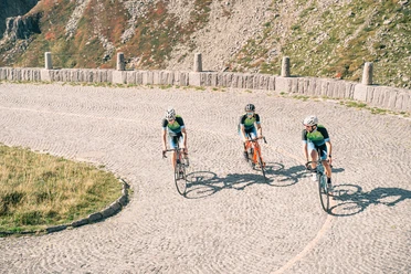
We start in Realp at the train station. This way we can warm up a bit until Hospental. After 6 kilometers, the road rises towards Gotthard. The ascent lasts 8 kilometers. Soon we are at Gotthard. Now follows the winding descent through the Tremola. A special experience that we do not want to miss, even though the descent is not so fast. In Airolo, we turn right towards the Bedretto Valley.
This ascent becomes longer and more arduous. 1400 meters of elevation gain up to 2478 meters above sea level. Shortly before the pass, the road reaches the watershed point at 2480 meters above sea level. The road over the Nufenen Pass is thus the highest mountain pass road located entirely within Swiss borders.
We can enjoy the descent down to Ulrichen. The Nufenen is usually not heavily trafficked by cars. Danger rather comes from motorcyclists.
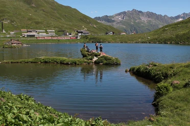
In Ulrichen, we turn east. A seven-kilometer rolling stretch lasts until the climb to the Furka. Now we mobilize our last reserves. In Gletsch, we can recover once again, the pass is already in sight and the last 7 kilometers of ascent lie ahead of us.
We arrive happy and satisfied at the Furka Pass. Now follows a long descent. In Tiefenbach, we take a last break, reflect on the day and enjoy once again the magnificent view of the Muttenhörner.
- 8:44 h
- 95.92 km
- 3,043 m
- 3,043 m
- 1,133 m
- 2,479 m
- 1,346 m
Good to know
Pavements
Best to visit
Tour information
Loop Road
Stop at an Inn
Author
Markus Fehlmann
Organization
Verein Urner Wanderwege
Author´s Tip / Recommendation of the author
Start in the early morning hours. Then there is hardly any traffic and you can enjoy the mountain world twice as much.
If you are tired at the end, you can also return from Oberwald to Realp by the Matterhorn-Gotthard Railway.
Nearby


Download GPX file