From Schwarzenberg to the Ochs summit
This ski tour is particularly unusual because you hardly gain any altitude during the first half of the ascent, instead following the path through the Grünenwald forest at a leisurely pace. It is only in the second half that you gain the necessary vertical meters to reach the special summit of Ochs.
- 2:00 h
- 5.23 km
- 641 m
- 39 m
- 985 m
- 1,588 m
- 603 m
- Start: Farm Bruedersrüti
- Destination: Ox
Good to know
Best to visit
Directions
Ascent:
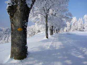
You start at the timber yard below the Bruedersrüti farm. You can park your car there. Follow the road towards Gustihütten for about 100 meters and then change to the dirt road until you reach the signpost at P.1080. Turn left towards Grüenenwald. Follow the forest path for an hour until you reach the Stächimoos junction. Continue along the hiking trail, which leads partly through the forest, until you reach Hinter Mülimoos. From there, there are several ways to reach the summit, although the summer hiking trail is recommended.
Descent:
The descent follows the same route as the ascent. In safe snow conditions, it is possible to ski directly from the summit to the Hinter Mülimoos hut. It is advisable to ski across the field at Grüenenwald to the Bruedersrüti farm.
Variant:
For those who do not want to go all the way to the summit or for those who want to take a short detour on the descent, the variant via Vorder Mülimoos is a good option. Instead of following the summer hiking trail to Hinter Mülimoos at the turn-off at the edge of the forest, turn off to Vorder Mülimoos. There you climb across the field to below the Regenflüeli. This way you can enjoy another beautiful descent before following the ascent route back to Bruedersrüti.
Directions & Parking facilities
Organization
Luzern Tourismus
Nearby