Jänzi Panorama Trail


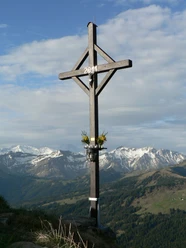
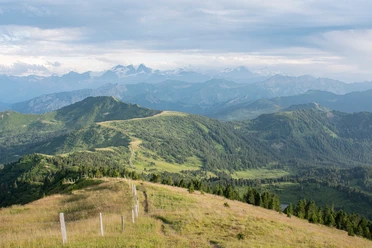
The hike begins at the Berghotel Langis, which is located right next to the large parking lot and the bus stop. The trail takes you past the Schwendi-Kaltbad restaurant, continuing along the meandering Schliere river into the Oberschlierental valley. From there, branch off eastwards at the bridge and walk along flowery meadows up to Egg. You reach the summit cross via the northern ridge, where a magnificent view awaits you. It is worth taking a short break there to enjoy your picnic. The way back leads over wide hills to Wolfetsmatt-Hohnegg and back to the Langis parking lot.
- 4:00 h
- 12.33 km
- 502 m
- 502 m
- 1,348 m
- 1,738 m
- 390 m
- Start: Mountain Hotel Langis
- Destination: Mountain Hotel Langis
Good to know
Best to visit
Directions
Tour information
Loop Road
Directions & Parking facilities
From Lucerne, change to the A8 in the tunnel in the direction of Interlaken, Sarnen and then continue on the A8 to the Sarnen Nord exit. Take the right lane and follow the signs to Stalden, Glaubenberg.
From Interlaken via Brünig on the A8 to the Sarnen Nord exit. At the exit, take the left lane and follow the signs to Stalden, Glaubenberg.
From Lucerne/Interlaken take the Lucerne-Interlaken-Express to Sarnen, change in Sarnen to the Postbus to Langis.
In winter, the buses run from mid-December to the beginning of April and the summer season lasts from mid-June to mid-October. At weekends in summer, there is also a connection to the Entlebuch line in Langis. Thanks to this connection, an attractive public transport round trip is possible, for example from Lucerne to Entlebuch, continuing by PostBus over the Glaubenberg Pass to Sarnen and back to Lucerne. The round trip is of course also possible in the opposite direction. www.postauto.ch/entlebuch
You can find current timetables here: www.sbb.ch or www.postauto.ch
Author
Obwalden Tourismus
Organization
Obwalden Tourismus

Nearby

Download GPX file