Fürstein Langis


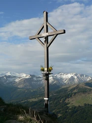
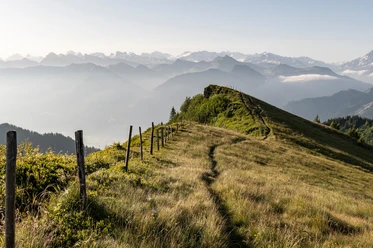
On the road behind the Passhöchi Beizli, the hike begins with the ascent to the left or right of the Rotbach in an open forest, steadily rising to Alp Rick. From there, the path leads up the steep summit slope to the cross on the Rickhubel. In a wide arc, the path continues on a plateau to the northeast ridge of the Fürstein, which is reached via a short steep slope. The panoramic view on the ring of Alps and up to the Jura is fantastic. After a short ridge descent southward, the path leads to Obersewen to the chapel and past the Sewenseeli to the saddle near Sewenegg. Varied on gentle slopes and through loose pine forest, it goes back over Schnabel to the parking lot.
If you do not want to climb all the way to the Fürstein, you can branch off left on the plateau and descend directly to Ober Sewen to the chapel. From the Langis bus stop, the circular hike takes about 30 minutes longer.
- 3:10 h
- 8.87 km
- 568 m
- 568 m
- 1,530 m
- 2,039 m
- 509 m
- Start: Glaubenberg Passhöhe parking lot
- Destination: Glaubenberg Passhöhe parking lot
Good to know
Best to visit
Tour information
Loop Road
Stop at an Inn
Directions & Parking facilities
From Lucerne or Interlaken take the Lucerne-Interlaken Express to Sarnen. From Sarnen, take the post bus to Langis.
Note: In the off-season, the post bus does not run all the way to Langis.
Author
Obwalden Tourismus
Organization
Obwalden Tourismus
Safety guidelines
This hike partly leads through military weapons and shooting ranges. During shooting, red/white flags, red/white balloons or (at night) 3 red lamps in a triangular shape are raised or placed at well-visible locations at the edge of the danger area and in the weapons positions. Entering the danger area is life-threatening and therefore forbidden. Instructions from the barrier guards must be followed. Here you can find the current shooting dates/notices. (Search: Glaubenberg/Wasserfallen)
Nearby

Download GPX file