Lindenberg trail


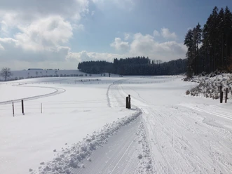
As soon as the grooming vehicle is in operation on the Horben, it means for cross-country skiers: strap on your skis. Beginners can warm up on a shorter practice loop (1.4 km). The longest trail, which leads into the neighboring canton of Lucerne, is the one over the Lindenberg. The elongated mountain ridge is easily accessible, making it a popular recreational area for the Freiamt, the Seetal, and the canton of Zug.
Another plus: the panorama above the sea of fog. This is already offered to skiers after the first short ascent over the fields: the view stretches over the Upper Freiamt to the Rigi and Titlis. The route continues past a rustic farmstead – always along the edge of the forest. Those who want to enjoy the view again can make a loop downhill back towards the restaurant. For ambitious skiers, the route branches off towards Lindenberg. Several sections of the Horben trail pass through the forest, where the snow-covered trees create a winter atmosphere.
Start and finish are located at the Horben alpine hut, which lies on the southeast side of the ridge, not far from Horben Castle. The building from the 18th century is a popular excursion destination and a cultural asset of national significance. It was once a retreat for monks of the Muri monastery, who wanted to unwind their souls in the seclusion of the Lindenberg.
- 2:30 h
- 11.15 km
- 99 m
- 99 m
- 775 m
- 862 m
- 87 m
Good to know
Best to visit
Tour information
Loop Road
Stop at an Inn
Directions & Parking facilities
There are parking spaces directly at the trail entrance on the Horben.
Bus stop Brunnwil, hamlet
Additional information
www.lindenbergloipen.ch/
Author
Seetal Tourismus
Organization
Seetal Tourismus
Nearby
Download GPX file