Maighelshütte SAC


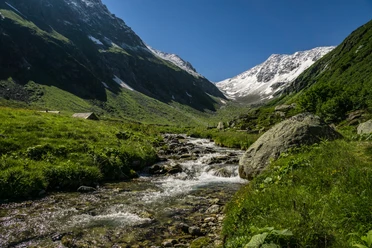
The scenic ascent to the Maighelshütte (2310 m above sea level) in the border area of Graubünden and Uri leads moderately ascending from the Oberalppass (2046 m above sea level) through the Val Maighels to the Urlaunsee.
The ascent path begins at the Oberalppass and leads from near the road up to an altitude of about 1980 m above sea level. Then it continues well signposted and marked towards Maighelshütte/Lai da Tuma, first flat, then mildly ascending along the eastern flank of the Pazolastock, until crossing the Rhine below Lai da Tuma.
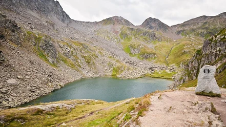
Soon you reach the Urlaunsee (Lai Urlaun) and after a short ascent the Maighelshütte (2310 m above sea level) on the flank of Piz Cavradi. From the hut, you enjoy a magnificent view of the Maighel Glacier and Piz Ravetsch. The hut is also an ideal starting point for multi-day hikes towards Ticino, to Capanna Cadlimo and Val Piora, or to the Vermigelhütte and Andermatt.
- 3:40 h
- 11.68 km
- 540 m
- 540 m
- 1,842 m
- 2,314 m
- 472 m
- Start: Oberalppass train station
- Destination: Oberalppass train station
Good to know
Pavements
Best to visit
Directions
Oberalppass - Trutg Nurschalas - Maighelshütte SAC - Oberalppass
Tour information
Loop Road
Nature Highlight
Stop at an Inn
Tour with Dog
Equipment
- Clothing appropriate to the weather
- Good footwear
- Hiking poles are recommended
Directions & Parking facilities
Hikers can reach the starting point by car via the Oberalppass from Andermatt or Sedrun via the Oberalppass road. Note that the road is closed in winter months due to snow.
There are parking facilities directly at the starting point Oberalppass. If the parking lots at the pass summit are all occupied, continue driving along the pass road towards Sedrun and park at the smaller parking lots on the side of the road.
Hikers can reach the Oberalppass by train from Andermatt or Sedrun. The timetable is as follows: Matterhorn Gotthard Bahn
Additional information
- Information about the hut can be found at: Maighelshütte SAC
For further questions, please contact: Andermatt holiday region, +41 41 888 71 00, [email protected]
Author
Andermatt-Urserntal Tourismus GmbH
Organization
Région de vacances Andermatt
Author´s Tip / Recommendation of the author
- Cairns in Val Maighels
- additional ascent to the Rhine source/Tomasee (approx. 1 hour)
- Lighthouse at the Oberalppass
Safety guidelines
- Hikers should keep an eye on the weather forecast in advance, as parts of the hike are over 2000 m above sea level and there can be light snowfall in extreme cases.
- Pay attention to the weather forecasts. In the Alps, there can be rapid weather changes.

Nearby

Download GPX file