North-south route: 4th stage Flüelen - Andermatt


The north-south route (SwitzerlandMobility Route 3) impressively connects the large Swiss landscape areas of the Jura, Central Plateau, Central Switzerland and the Alps as far as southern Switzerland. It follows historic transport routes and passes through numerous culturally significant places.
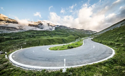
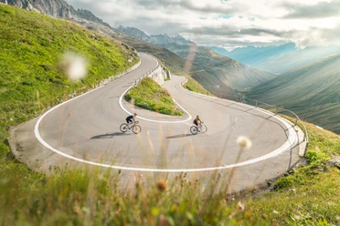
Stage 4 starts in Flüelen on Lake Uri and leads steadily uphill through the Reuss Valley in Uri to Andermatt. Steep rock faces, lush green meadows, winding roads and impressive views of the wild Reuss await you along the way.
A particular highlight is the ride through the historic Schöllenen Gorge with the famous Devil's Bridge - a landmark of the Gotthard crossing of the Alps. From Andermatt, the route continues over the Gotthard Pass towards Faido.
- 2:40 h
- 38.73 km
- 1,012 m
- 11 m
- 434 m
- 1,439 m
- 1,005 m
- Start: Flüelen railroad station
- Destination: Andermatt train station
Good to know
Pavements
Best to visit
Directions
Tour information
Nature Highlight
Stop at an Inn
Equipment
- Clothing appropriate to the weather
- Provision of food and drink
- Bicycle light
Directions & Parking facilities
You can reach the starting point in Flüelen by train or bus. The timetable is as follows: SBB timetable
Additional information
Author
Andermatt-Urserntal Tourismus GmbH
Organization
Région de vacances Andermatt
Author´s Tip / Recommendation of the author
- Church of Wassen
- Circular route through the Schöllenen Gorge
- This stage is also ideal in the opposite direction
Safety guidelines

Nearby

