Oberland Bike: Amsteg - Andermatt


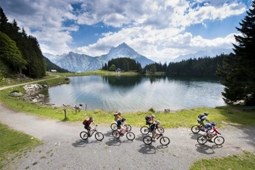
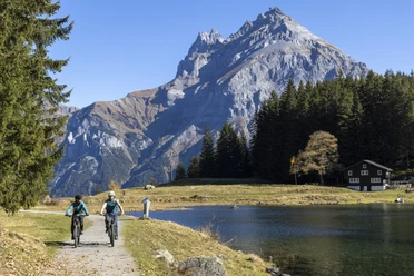
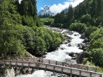
From Amsteg, bikers ride after a short ascent on the Gotthard mule track to Meitschligen. From the eastern valley flank between Gurtnellen and Wassen, the trains winding up the upper Reuss valley over bridges, viaducts, and hairpin tunnels can be observed very well. Behind Wattingen, you pass under the canopy of the St. Joseph chapel, built in the 18th century. The route continues along a magnificent forest path via Neiselental to Göschenen. Along the steep rock walls of the Schöllenenschlucht and the Urnerloch, the first tunnel in the Alps, the turning point Andermatt is reached. The return journey leads over the mountain road to Gurtnellen village. Then follows an attractive descent over field paths to Meitschligen, then the same way back to Amsteg.
- 6:45 h
- 44.69 km
- 1,291 m
- 1,291 m
- 522 m
- 1,440 m
- 918 m
- Start: Amsteg, Post
- Destination: Amsteg, Post
Good to know
Pavements
Best to visit
Directions
Amsteg - Gurtnellen - Göschenen - Andermatt - Amsteg
Tour information
Loop Road
Nature Highlight
Stop at an Inn
Equipment
- Clothing appropriate to the weather
- Bike light (especially for tunnels)
Directions & Parking facilities
From the A2 motorway, the starting point can be reached via the Amsteg motorway exits.
Parking is available directly in Amsteg, both in and outside the village.
The starting point Amsteg is easily accessible by the Auto AG bus. The Auto AG timetable is as follows: Auto AG Uri timetable
Additional information
If you have any further questions, feel free to contact: Andermatt holiday region, +41 41 888 71 00, [email protected]
Author
Andermatt-Urserntal Tourismus GmbH
Organization
Région de vacances Andermatt
Author´s Tip / Recommendation of the author
- Schöllenenschlucht with Devil's Bridge and Suworow monument
- Walking tour through Andermatt
- Chileli of Wassen
Safety guidelines
Parts of the route are also used by regular traffic (cars, local bus)
Nearby


Download GPX file