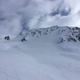
How would you like to arrive?
Download GPX file
- 04:30 h
- 700 m
- 1,293 m
- 1,436 m
- 2,739 m
- 1,303 m
- 11.83 km
- Start: Train station Oberalppass
- Destination: Train station Andermatt
Father Placidus A. Spescha (1752 - 1833) already described Lake Toma as follows: "The lake which is 200 paces wide and 400 paces long is the basin from which the Anterior Rhine originates. The area is one of astounding beauty and therefore worthy of being the primary source of such a river."
The tour begins on the Oberalp Pass just behind the lighthouse which is a replica of the former lower range light in the Hook of Holland and is intended to bridge the distance from the source to the mouth of the Rhine. Rising gently initially, the route then forms short hairpin bends and leads to the first waypoint, the summit of the Pazolastock. A stony, airy ridge needs to be overcome before the Fil da Tuma is reached, but you can always cling to the many boulders the line the route. The route passes alongside the Badus mountain shelter. Having passed the shelter, a 20 minute downhill walk will bring you to Lake Toma. Solitude is something rare here, but you will always be able to find suitable spots at which to rest and stay a little longer. Be it on one of the large stones with views of the lake or on some of the green groundcover right around the lake. The route back to the Oberalp Pass leads past the eastern flank of the Pazolastock. In summer, the sweet-smelling Turk's cap lily flowers here.
Good to know
Best to visit
Directions
Tour information
Loop Road
Summit
Equipment
- Clothing appropriate for the weather
- Sturdy footwear
- Hiking poles are recommended
- Binoculars
- Camera
- Daypack
Directions & Parking facilities
Mit dem Auto erreichen Wanderer den Startpunkt über den Oberalppass von Andermatt oder Sedrun aus. Empfohlen wird jedoch das Auto in Andermatt zu parkieren und mit dem Zug auf den Oberalppass zu fahren, da der Start- und Zielpunkt nicht derselbe ist.
Wenn Sie jedoch die Alternativroute wählen und daher vom Pazolastock zurück zum Oberalppass gehen und nicht nach Andermatt, fahren SIe von Andermatt aus zum Nätschen hoch und weiter zum Oberalppass an der Oberalppassstrasse entlang.
Empfohlen wird das Auto in Andermatt zu parkieren und mit dem Zug auf den Oberalppass zu fahren, da der Start- und Zielpunkt nicht derselbe ist. In Andermatt findet man direkt beim Bahnhof Parkmöglichkeiten. Alternativ gibt es jedoch auch auf dem Oberalppass Parkplätze.
Mit dem Zug gelangen Wanderer von Andermatt oder Sedrun aus zum Oberalppass. Der Fahrplan ist folgender: Matterhorn Gotthard Bahn
Additional information
Bei weiteren Fragen melden Sie sich gerne bei: Ferienregion Andermatt, +41 41 888 71 00, [email protected]
Author
Andermatt-Urserntal Tourismus GmbH
Organization
Ferienregion Andermatt
Author´s Tip / Recommendation of the author
- Tomasee
- Light house Oberalp pass
Safety guidelines
Wanderer sollten im Voraus den Wetterbericht im Auge behalten, da sich Teile der Wanderung auf über 2000 m.ü.M. befinden und es daher im Extremfall zu leichtem Schneefall kommen kann.