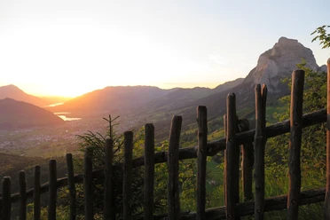
Rotenflue circular route


Discover the panoramic circular trail on the Rotenflue for a relaxed hike with impressive views. Two idyllic barbecue spots invite you to linger and picnic.
If you want to indulge in culinary delights, there are two places to stop for refreshments along the way: The Gipfelstubli restaurant right by the mountain station delights with regional delicacies from the summit menu and a varied dessert menu, while the Berggasthaus Rotenfluh offers simple menus and fine desserts - both welcome their guests with a warm atmosphere and fantastic views.
The start and finish is the Rotenfluebahn mountain station - the ideal starting point for a nature experience away from everyday life.
The circular trail on the Rotenflue is easy to walk and is suitable for families with small children and senior citizens.
Grand tour
Rotenflue mountain station - Stägleren - Rotenfluh mountain inn - Rotenflue mountain station
Hiking time 45 mins
Small tour
Rotenflue mountain station - Rotenfluh mountain inn - Rotenflue mountain station
Hiking time 33 min
- 0:45 h
- 2.26 km
- 77 m
- 77 m
- 1,495 m
- 1,572 m
- 77 m
- Start: Rotenflue mountain station
- Destination: Roteneflue mountain station
Good to know
Best to visit
Tour information
Loop Road
Mountain Railway Tour
Stop at an Inn
Equipment
Directions & Parking facilities
From Zurich, you can reach the Mythen region via the A3 highway to the Einsiedeln exit. From Einsiedeln, continue to Brunni-Alpthal.
The AAGS bus takes you comfortably from Schwyz railroad station to the Rotenfluebahn.
Bus station: Rickenbach SZ, Rotenfluebahn
Additional information
Author
Erlebnisregion Mythen
Organization
Schwyzer Wanderwege
Nearby

Download GPX file